The prairie can hide an entire landscape in plain sight. Around Drumheller, the ground falls away into layered canyons, winding coulees and the cottonwood-lined Red Deer River. Follow the valley east and the story changes again, coal towns and weathered buildings give way to open ranch country before the road drops into the fossil-rich terrain of Dinosaur Provincial Park.
This is a trip worth taking slowly. Give yourself three to five days to hike, follow side roads, paddle a stretch of river and spend a night or two beneath the Badlands sky. From north to south, here are a few of our favourite outdoor adventures on an Alberta Badlands Road Trip.
Walk the Badlands at Midland Provincial Park
Midland Provincial Park is found just west of Drumheller where trails thread through eroded hills and remnants of the valley's coal-mining past. The Badlands Interpretive Trail brings you into the landforms you will be seeing from the road for the rest of the trip, while the Midland Coal Mine Interpretive Trail adds a more recent chapter to the area's history. Walk the trails in the cooler part of the day, then leave time for a visit to the Royal Tyrrell Museum (tyrrellmuseum.com), which sits within the park.
 Southern Alberta Backroad Mapbook - map page 55
Descend into Horseshoe Canyon
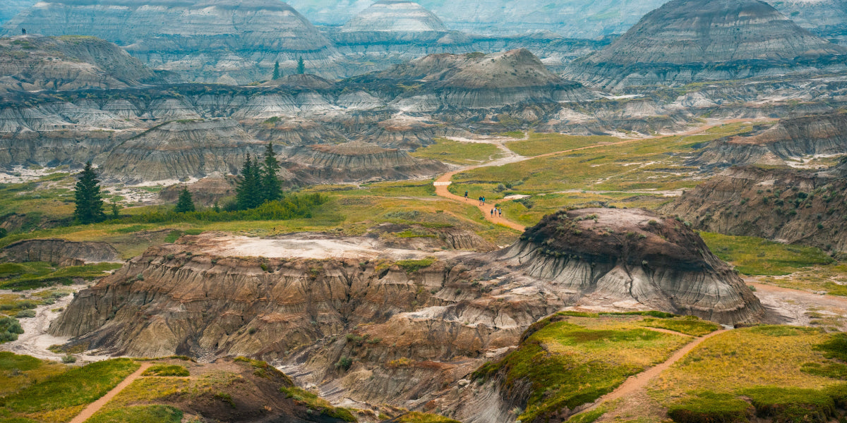
The view from Horseshoe Canyon's rim is a perfect introduction to the spectacular scale of the Badlands. Just west of Drumheller off Highway 9, the prairie opens suddenly into a maze of striped slopes and gullies. Pause at the viewpoints, then follow the descent to the canyon floor for a closer look at the changing layers. Factoring in the return climb and exposed terrain, visiting the canyon is best done earlier on a hot day. Keep an eye on conditions after rain as clay that feels firm when dry can turn slick underfoot.

Drive the Dinosaur Loop Trail
Running northwest out of Drumheller, this 48 km (30 mile) loop heads north on Highway 838 on the east side of the Red Deer River, crosses the river on the Bleriot cable ferry and returns to Drumheller on Highway 837. Horsethief Canyon offers a viewpoint over a wide, deeply eroded section of the valley reached just before the ferry which has been carrying vehicles across the river since 1913. The loop then takes a short detour to the Orkney Viewpoint as it makes its way back to Drumheller. Feel free to pull over where it is safe, let the valley set the pace and watch how the colours of the hills change through the day.

Horsethief Canyon on Backroad Maps Web Map
Camp Beneath the Cottonwoods at Bleriot Ferry
Looking for an overnight stop? The Bleriot Ferry Provincial Recreation Area, found just south of the ferry crossing, offers a small campground beside the Red Deer River. Cottonwoods provide shade, and the river is close enough to make a shoreline wander part of the evening. Bring your own drinking water as the campground does not provide it. Camping is $25 per night, cash or cheque only. Visit albertaparks.ca for more information.

Bleriot Ferry
Follow the Red Deer River by Canoe
From the water, the Badlands become a different place. Cottonwood groves, bends in the Red Deer River and the changing cliff faces unfold at paddling speed, far from the viewpoints above. A launch near Bleriot Ferry offers one option while farther southeast, a 13 km (8 mile) paddle from the Steveville area to the Dinosaur Provincial Park campground features exceptional scenery.
Take the Hoodoo Trail East
Back in Drumheller, turn southeast for a different scenic drive. The Hoodoo Trail follows the valley past Rosedale for 16 km (10 miles) to Willow Creek and the sandstone formations that have become one of the region's best-known sights. Stop for a short walk, then carry on to East Coulee and the Atlas Coal Mine National Historic Site. Together, the landforms and mine tell a story that goes beyond dinosaurs, when rivers shaped the valley, and coal later brought communities to its floor. Leave time for the little stops along the way. This drive works best when you can pull over and explore without time constraints.

Southern Alberta Backroad Mapbook - map page 43
Wind Through the Bridges to Wayne
At Rosedale, Highway 10X turns into a memorable side trip through a narrow coulee to Wayne. The eleven narrow, single-lane, wooden-planked bridges, close valley walls and quiet road make the drive itself the attraction, with the historic 1913 Last Chance Saloon (Rosedeer Hotel) waiting in the hamlet at the end. Stop for lunch and check out the bullet holes in the walls and the memorabilia-lined walls. There are around 28 permanent residents today, compared to a peak of over 2,000 during the coal-mining boom of the 1920s and 1930s. Wayne is a detour from the eastward journey, so allow time to enjoy the return drive before continuing toward East Coulee.
Find the Quiet Roads to Dorothy
Farther southeast of Drumheller, Dorothy offers a change of pace from the busy hoodoo stops. The small former prairie settlement is known for its historic churches and weathered buildings set against open sky. Dorothy fits the backroad spirit of this trip where the pleasure lies in following a quieter route, stopping where the landscape catches your eye and giving a small place time to tell its story.

Dorothy
Cross the Prairie to Steveville
The final leg of the road trip leads towards Dinosaur Provincial Park. Alberta Parks recommends approaching the park through Brooks with drivers coming from the north connecting to Highway 544 via Highway 36. Near the park's northwestern side, Steveville Bridge Campground offers a rustic overnight option beside the Red Deer River. Its small sites suit self-sufficient tent campers and smaller units, with no water or cell service provided. Visit albertaparks.ca for more information.

Hike Dinosaur Provincial Park's Public Trails
The final descent into Dinosaur Provincial Park is one of the trip's great reveals. From the entrance viewpoint, badlands ridges spread across the Red Deer River valley. Below are self-guided trails, cottonwood groves and outdoor fossil displays. Walk one or several of the sixteen inter-connected hiking trails, take time at view the outdoor displays, check out the Visitor Centre and return for a different view as the sun drops lower. Stay on designated routes, leave fossils where they are and check trail conditions at albertaparks.ca, especially after rain.

Venture Deeper on a Guided Tour
To see more of Dinosaur Provincial Park's protected fossil country, make a guided tour the centrepiece of your visit. Interpretive hikes and tours enter areas of the natural preserve that visitors cannot explore independently, adding a sense of discovery to the striking scenery. Programs are popular in summer, so choose your tour before settling the rest of your schedule. Tour details and reservations are available through albertaparks.ca.
Spend a Night in the Fossil Country
Stay at Dinosaur Provincial Park after the day visitors leave. Its campground lies among cottonwoods near the Red Deer River, providing a base for an evening walk and an early start on the trails. It offers tent and RV sites, with electricity, showers and flush toilets. Reserve ahead as the park is a popular summer destination. An overnight stay gives this Badlands road trip a fitting finish with quiet valley air, darkening hills and another chance to watch the Badlands change with the light.

Plan the Journey
Allow at least three days: one for Drumheller's hikes and Dinosaur Trail loop, one for the Hoodoo Trail, Wayne and Dorothy detours, and one for the drive to Dinosaur Provincial Park and its public trails. Add a fourth and even a fifth day for a guided park tour, a carefully planned paddle or to explore even more of the park’s trails. Bring water and sun protection, expect exposed hiking terrain and avoid clay roads and trails when wet. For current information to help plan your trip, visit alberta.ca, rivers.alberta.ca and albertaparks.ca.
The Alberta Badlands reward anyone willing to slow down. From Tyra, the world’s largest dinosaur at 25 metres (86 feet), follow the backroads out of Drumheller, take the short walk that was not on the original plan and leave room for one more sunset beside the river. By the time you reach Dinosaur Provincial Park, the drive will have become as memorable as the destination.
Ready to explore the rugged Southern Alberta Badlands? Pick up a copy of the new Southern Alberta Backroad Mapbook or download the Backroad Maps app for both IOS and Android to help plan your adventure. And don’t forget to tag us in your photos #brmblife.