Unlock the Outdoors with 25% Off! Ends December 2nd, 2024

Vancouver Island North BC - Recreation Map

Vancouver Island BC 💧 Waterproof Map
$1695 $1995

Barcode: 6-22098-11009-8

Specs

Map Scale: 2 sides @ 1:180,000
Release:
2021
Dimensions: 86 x 117 cm (34 x 46.25 inches)

Area Covered

Alert Bay, Campbell River, Cape Scott, Coal Harbour, Comox, Courtenay, Cumberland, Gold River, Holberg, Kyuquot, Port Alice, Port Hardy, Port MacNeill, Powell River, Sayward, Strathcona Park, Tahsis, Telegraph Cove, Woss, Zeballos and more

Map Features

Highways, Logging Roads, Land & Water Features, Parks, Adventure Points of Interest, Campgrounds, Hiking Trails, Motorized Trails, Paddling Routes, Hunting & Fishing Areas, Winter Recreation and More.

Description

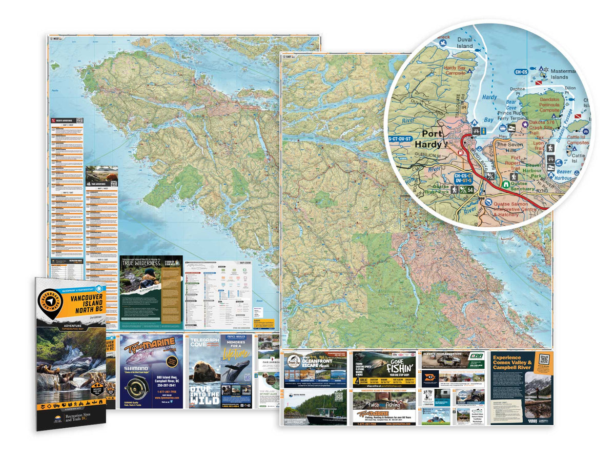
VANCOUVER ISLAND BC NORTH WATERPROOF ADVENTURE MAP

Featuring vast stretches of undisturbed rainforest, towering mountains surrounded by pristine lakes, thousands of kilometers of coastline teeming with marine life and a variety of quaint, charming communities, Northern Vancouver Island offers endless opportunity for adventure. With just one major roadway reaching the northern extents of the Island, this is a place where nature rules and stress melts away. A secluded sandy beach or isolated campsite is never too far away, and often your chances of seeing a whale swimming offshore are better than spotting another human. From salmon fishing in Campbell River to hiking in Strathcona Park and Cape Scott or paddling the shores of Brooks Peninsula Park, there is no shortage of recreational opportunity on Northern Vancouver Island.

To make navigating this sparsely populated region easier the BRMB team have worked tirelessly to create the most comprehensive, detailed and easy to use map for Northern Vancouver Island you will find anywhere. This dual sided 34” x 46.25” map is printed on durable, waterproof paper to withstand any storm or gale. With industry-leading cartographic detail, state-of-the-art relief shading, colour coded Provincial Parks and more, there isn’t an easier to read map on the market. This map contains countless points of interest, hiking trails, campsites, beaches, paddling routes and more, so no matter what you are looking for, you can find it on our Northern Vancouver Island Waterproof Map. This map also features detailed descriptions of recreation sites and parks with information on camping, fees, activities, access and more. Covering the areas around Port Hardy, Port McNeill, Gold River, Campbell River, Courtenay/Comox and more, this is your ultimate guide to exploring one of the most breathtaking areas in the world.

Looking for a different area?

Browse our TOPO Maps: Zoom into your province to see the map grid, then click on any of the highlighted areas to select your TOPO Map

Vancouver Island North BC - Waterproof Recreation Map - Recreation Map

Vancouver Island North BC - Recreation Map

$1695 $1995
VANCOUVER ISLAND BC NORTH WATERPROOF ADVENTURE MAP Featuring vast stretches of undisturbed rainforest, towering mountains surrounded by pristine lakes, thousands of kilometers of coastline teeming with marine life and a variety of quaint, charming communities, Northern Vancouver Island offers endless opportunity for adventure. With just one major roadway reaching the...

Scale

2 sides @ 1:180,000

Area

Alert Bay, Campbell River, Cape Scott, Coal Harbour, Comox, Courtenay, Cumberland, Gold River, Holberg, Kyuquot, Port Alice, Port Hardy, Port MacNeill, Powell River, Sayward, Strathcona Park, Tahsis, Telegraph Cove, Woss, Zeballos and more

Dimensions

86 x 117 cm (34 x 46.25 inches)

Pages

2

Release

2021

Features

Highways, Logging Roads, Land & Water Features, Parks, Adventure Points of Interest, Campgrounds, Hiking Trails, Motorized Trails, Paddling Routes, Hunting & Fishing Areas, Winter Recreation and More.
View product