This guide compares the top 5 fishing maps in Ontario for spring anglers, including fishing apps and printed fishing map books. Learn how fish maps Ontario options like Backroad Mapbooks, Canada TOPO Maps, and Angler’s Atlas help with trip planning, lake access, depth contours, and species information across Ontario Canada.
Spring fishing in Ontario hits differently.
Ice-out opens up thousands of lakes and rivers, walleye slide shallow, pike prowl warming bays, and anglers across the province start planning weekends around water levels, access points, and timing.
That planning almost always starts with a fishing map!
Ontario is massive.
Over 250,000 lakes, countless rivers, and multiple management zones mean guessing your way through spring simply wastes time.
The right fishing maps, printed, digital, or both, help you understand where fish stage, how to reach them legally and safely, and how conditions change week to week.
Below is a deep, honest look at the top 5 fishing maps in Ontario that spring anglers rely on most.
This covers apps and printed maps, how they differ, what they show, and who each one really works best for.
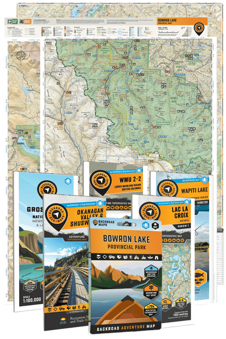
1. Backroad Maps – Outdoor Adventure Maps (Print & App)
Print | Web Map | iOS App | Android App
If you fish Ontario seriously, especially in spring, Backroad Maps almost always ends up in your gear pile or on your phone.
It’s the rare case where printed maps and digital tools actually complement each other instead of competing.
Overview
Backroad Maps began as a printed atlas series designed for hunters, anglers, and backcountry travellers who needed accurate, detailed access information.
Over time, that same depth of data expanded into a powerful digital platform while keeping the printed books fully relevant.
What separates Backroad Maps from most fishing apps is context. You’re not just looking at depth lines or GPS dots.
You’re seeing the whole picture: lake access points, forest roads, canoe routes, portages, fish species distribution, stocking info, regulations references, and land-use boundaries.
If you’re the type of angler who likes studying lakes before the season opens, the
Backroad Maps team regularly shares seasonal tips, species breakdowns, and planning advice on their fishing blog, it’s a solid resource when you’re narrowing down where to fish next.
Coverage in Ontario
Ontario coverage is extensive and province-wide.
Each regional book breaks down lakes, rivers, and access roads across vast areas that most apps barely touch.
Northern Ontario, crown land zones, fly-in lakes, backroad-access fisheries, and canoe-country routes are all well represented.
Digitally, the Backroad Maps App allow you to explore:
- Lakes and rivers across Ontario
- Remote access points and boat launches
- Fishing-relevant road networks often missing from standard map apps
- Overlaid fish species data by waterbody
This matters in spring when water access changes fast and conditions can turn a simple trip into a long detour if you’re missing local knowledge.
Fishing-Specific Features
Backroad Maps isn’t flashy. It’s thorough.
Key fishing features include:
- Fish species listings for lakes and rivers
- Access points clearly marked for boats, canoes, and shore fishing
- Portages and canoe routes for spring backcountry trips
- Depth shading and hydrographic data where available
- Crown land and protected area boundaries
- Integration with GPS for on-water and off-road use
The Backroad Maps app lets you layer information so you’re not bouncing between five different tools.
You can plan at home, then use the same data offline once you’re out of cell range.
Best Backroad Maps For Fishing in Ontario
Trip Planning: Backroad Mapbooks series
For many anglers, planning starts with a printed book.
The Ontario Backroad Mapbooks series gives you a clear overview of an entire region. If you’re heading somewhere unfamiliar, this is where things begin to make sense fast.
Each lake is labelled with fish species, and stocked species are clearly marked in orange.
That detail alone saves hours of searching through scattered sources. You’re not guessing which lakes hold walleye, trout, bass, or pike; it’s right there.

On the Go: BRMB Maps app
Once you leave the house, the BRMB Maps app takes over.
This is where things get especially useful for spring anglers.
The app includes clearly classified fishing hotspots:
- Stocked lakes
- Non-stocked lakes
- Stream fishing
- Ocean fishing
- No-fishing areas (clearly labelled)
The app continues to improve with regular updates, and the recent BRMB Maps Fishing Update (v3.4) introduced even more fishing-focused enhancements for anglers exploring Ontario waters.
Each point of interest includes:
- A description
- Species information
- Key stats
- Access details
That last part matters more than people realize. Access can make or break a spring trip.
The app also includes:
- Extensive road and trail information (often unmatched for remote areas)
- Fishing Regions and Crown Land overlays
- Ocean charts where applicable
- Satellite and hybrid map views
- Downloadable offline maps
- Turn-by-turn navigation to fishing hotspots
For anglers who like exploring backroads, forest access routes, or lesser-known lakes, that road and trail data is a huge advantage over many fishing-only apps.
Used together, print and digital create a planning system that’s hard to beat.
If you want a deeper look at how anglers are using it, their detailed overview of the BRMB Maps fishing app features walks through everything included. Feel free to download the apps here: iOS | Android

In the Field: Waterproof Folded Maps
Sometimes you don’t want a full book. And sometimes you don’t want to rely on your phone. That’s where the Ontario Waterproof Folded Maps come in.
These provide greater detail than the regional books and are designed specifically for field use. You can clearly see:
- Boat launches
- Access points
- Portages
- Depth information (where available)
They’re tough, practical, and easy to keep in a boat compartment or dry bag.
Strong examples include:
- Algonquin Provincial Park [New Edition] Recreation Map
- Killarney Provincial Park Map
- Kawartha Highlands Provincial Park Map
- Lake Nipigon Destination Map
Plus, there are many print-on-demand options for lakes across the province.
For anglers who fish wet, windy, early-season conditions, a physical backup is never a bad idea.

For Advanced or Remote Travel: Garmin GPS Maps
Most anglers will find the BRMB Maps App covers what they need. But for those heading into extremely remote areas, long canoe routes, northern fly-in regions, extended backcountry trips, Garmin GPS Maps are available.
The mapping information is very similar to what you’ll find in the app (with some limitations), but Garmin devices offer:
- Strong battery life
- Rugged durability
- Reliability in extreme conditions
If your spring fishing involves true off-grid travel, dedicated GPS hardware can be a worthwhile addition.
If you're deciding between using your phone or a dedicated GPS unit, this App vs GPS Maps comparison explains the differences in more detail.
Pricing
- Ontario Printed Mapbooks: Typically a one-time purchase per region
- Backroad Mapbooks Maps App: Subscription-based with free trial
For the amount of Ontario fishing data included, the value is strong, especially compared to stacking multiple single-purpose apps. Feel free to shop here for exact pricing.
Best For
- Spring anglers exploring new water
- Remote and backroad fishing trips
- Canoe anglers and fly-in planning
- Anglers who want fishing maps plus access info
- Anyone who prefers having a printed fishing map book as backup
2. Angler’s Atlas – Interactive Fishing Maps
If you enjoy researching lakes before you ever launch the boat, Angler’s Atlas can be a powerful planning tool.
It’s one of the more established names in the Ontario Canada fishing maps space, and it leans heavily into lake databases and angler-contributed information.
Overview
Angler’s Atlas blends bathymetric mapping with a large, searchable database of lakes across Ontario.
It doesn’t try to replace your GPS or your printed fishing map book. Instead, it focuses on helping you answer questions before the trip:
- What species are in this lake?
- Has it been stocked?
- What do other anglers say about it?
- What’s the depth profile like?
That research-first approach makes it particularly helpful during early spring, when anglers are trying to narrow down options after ice-out.
MyCatch Fishing App
Angler’s Atlas also offers the MyCatch Fishing App, which extends its ecosystem onto your phone.
MyCatch allows anglers to:
- Explore fishing areas
- Log and track catches
- Record species and sizes
- Add photos
- Contribute to citizen science and fishery data
- View lake maps tied to your fishing history
For anglers who like keeping personal records or contributing to fish population data, this adds a layer beyond simple mapping.
Over time, you build a digital fishing journal connected to specific waterbodies.

Coverage in Ontario
Coverage is broad across Southern and Central Ontario and extends well into the north.
Smaller lakes that don’t always appear in high-end marine apps are often listed here with species and stocking data.
This is especially helpful when exploring secondary lakes outside well-known systems like Simcoe, Nipissing, or Lake of the Woods.
Key Features
- Detailed bathymetric maps on many Ontario lakes
- Fish species listings
- Stocking data references
- Community fishing reports
- Web-based mapping interface
- GPS-enabled mobile access

The community reports are a double-edged sword. They can provide timely insight, but quality varies.
Still, during spring when patterns are shifting fast, even anecdotal updates can help steer planning.
Pricing
- Free access with limited functionality
- Premium subscription unlocks advanced map layers and expanded data
Best For
- Pre-trip lake research
- Finding lesser-known waters
- Anglers who enjoy digging into stocking history
- Comparing multiple lake options before choosing one
It’s not a full outdoor access solution like Backroad Maps, but as a database-driven Ontario fishing map resource, it fills a useful niche.
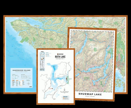
3. Lake Simcoe Fishing Maps & Nautical Charts
When it comes to Lake Simcoe fishing maps, local detail matters. This isn’t just another lake, it’s one of Ontario’s most intensively fished bodies of water, especially in spring for lake trout, perch, and whitefish.
Overview
Lake Simcoe Outdoors provides dedicated nautical charts and fishing maps specific to Lake Simcoe.
Unlike broader Ontario fishing maps that generalize coverage, these charts go deep into one system.
Spring anglers benefit from understanding:
- Deep basins for post-ice lake trout
- Shallow warming bays for perch
- Shoals and humps that concentrate fish
- Navigation hazards during fluctuating water levels
Coverage
Exclusively Lake Simcoe. That narrow focus is actually its strength. The level of structural detail is higher than what you’ll typically see in generalized apps.

Key Features
- High-resolution bathymetric contour lines
- Clearly marked shoals and reefs
- Navigation references
- Print-ready chart formats
- GPS-compatible options for boat electronics
If you spend multiple weekends each spring on Simcoe, a specialized lake simcoe fishing map often proves more precise than multi-lake platforms.
Pricing
- One-time purchase per chart or format
Best For
- Anglers who fish Simcoe heavily
- Tournament anglers
- Early-season lake trout hunters
- Boat anglers requiring precise structural awareness
It’s not designed for province-wide exploration. It’s built for mastering one lake.
4. TrakMaps Canada Fishing Maps (Printed Charts & Garmin GPS)
TrakMaps operates with a straightforward philosophy: clear printed charts, accurate contours, no fluff.
Overview
Their fishing maps are traditional printed charts focused heavily on bathymetric detail. While they also produce GPS-compatible products, their printed fishing maps remain popular among anglers who prefer paper reliability.
Spring fishing often means cold weather, wet boats, and electronics that don’t always cooperate. A laminated or durable printed chart remains practical in those conditions.

Coverage in Ontario
Coverage is selective rather than province-wide. Many popular Ontario lakes are included, but not all.
This makes TrakMaps best suited to anglers who repeatedly fish the same few systems.
Key Features
- Clear contour intervals
- Durable print quality
- Easy-to-read layout for on-boat reference
- Select GPS compatibility
Unlike digital-first fishing apps, these charts won’t provide species listings or access road detail. They focus squarely on underwater structure.
Pricing
- One-time purchase per map
Best For
- Anglers who prioritize contour clarity
- Boat anglers who prefer paper backups
- Focused use on specific lakes
For structure-based spring species like lake trout and walleye, contour clarity is often more important than extra features.
5. Canada Topo Maps App – Outdoor Navigation + Depth Overlays
Canada Topo Maps sits somewhere between hiking GPS and fishing app.
Overview
Built primarily around Canadian topographic data, this app overlays terrain, elevation, and in some cases depth information. It’s useful for anglers who spend as much time getting to lakes as they do fishing them.
Spring in Ontario often means muddy access roads, snow patches in the north, and tricky portages. A topo-focused map can help anticipate terrain challenges before you commit.
Coverage
Nationwide, including remote Ontario regions. Depth detail varies depending on available hydrographic data.
Key Features
- Canadian topo map layers
- GPS tracking
- Waypoint marking
- Offline downloads
- Optional marine overlays
It’s not a fishing-specific app first. It’s a navigation tool that can support fishing.

Pricing
- Free basic version
- Paid upgrades unlock advanced layers
Best For
- Canoe anglers
- Backcountry lake explorers
- Anglers combining hiking and fishing
If your spring trips involve portages or crown land access, topo data becomes valuable fast.
Why Ontario Fishing Maps Matter More in Spring
Spring conditions shift quickly.
Water temperatures, spawning closures, access roads, and boat launches can change weekly.
Fisheries and Oceans Canada research shows spring water temperature plays a major role in fish location and feeding behaviour across species.
Accurate Ontario fishing maps reduce guesswork when those changes happen fast.
Frequently Asked Questions
What is the best fishing map for Ontario?
For overall coverage, access information, and fishing context, Backroad Mapbooks stands out. It combines printed reliability with digital convenience across the province.
Are fishing apps better than printed fishing maps?
Apps offer GPS and live positioning. Printed Ontario fishing maps excel at planning and reliability when batteries fail. Many anglers use both.
Do fishing maps show fish locations?
Most maps show structure, depth, and species presence. They don’t show real-time fish positions, but they show where fish typically relate during spring.
Are free Ontario fishing maps accurate?
Some are. Many free apps rely on limited data or crowdsourcing. Paid maps usually offer better consistency and coverage.
What’s the best fishing app for remote Ontario lakes?
Backroad Mapbooks Maps App and Canada Topo Maps perform well offline and include access information crucial for remote trips.
Final Thoughts
Ontario fishing rewards preparation.
The right fishing maps help you understand water before you ever make a cast, especially during spring when conditions are constantly shifting.
Be sure to pick up a copy of our printed fishing maps to make planning your next day on the water simple and reliable.
Prefer digital? Explore lakes, rivers, and access points using the BRMB Map App, packed with fishing information and outdoor adventures across Canada. You can also explore the web version of the BC fishing adventures hub on BRMB Maps, which is useful for trip planning on a desktop the night before.