


Walleye Fishing in Saskatchewan: Best Lakes, Limits & Tactics (2026 Guide)
Walleye fishing in Saskatchewan is some of the best in Canada. You need an angling licence from age 16, the general limit is four walleye with only one over 55...


Couldn't load pickup availability
ISBN: 978-1-989175-55-2
UPC: 622098111729
Release: 2025
Edition: 2nd Edition
Dimensions: 5x8.25 inches (folded) / 27.8×39.4 inches (unfolded)
Map Scale: 1:58,000 Scale
Double-Sided
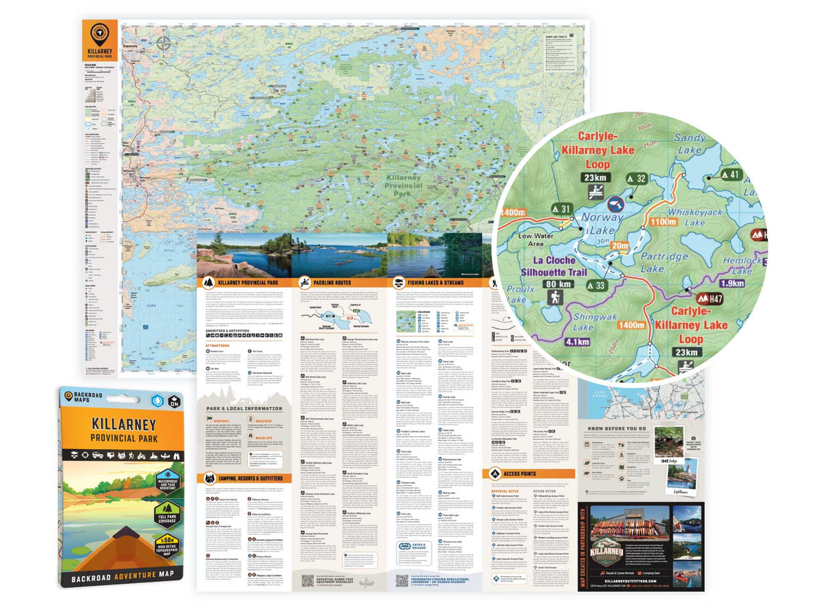
Killarney Provincial Park Ontario - Park Map
1:58,000 Scale
Large Format
5x8.25 inches (folded) / 27.8×39.4 inches (unfolded)
Waterproof & Tear-Resistant
Covering Killarney Provincial Park in Northern Ontario, this map features the hiking trails, canoe routes, access points, campsites, lakes and visitor facilities. This Adventure map includes 1:10,000 water and trail data and can be used for hiking, canoeing, camping, exploring, fishing, kayaking, skiing, wildlife viewing and more!
Covering 640 sq. km (247 sq. mi), this map includes Killarney Provincial Park, Killarney, Baie Fine, Bell Lake, Crooked Lake, George Lake Campground, Johnnie Lake, Kakakise Lake, La Cloche Mountains, La Cloche-Silhouette Trail, Lake Panache, Nellie Lake, Osa Lake, Threenarrows Lake and more!
The printed version of the map is displayed at 1:58,000 scale on 5x8.25 inches (folded) / 27.8×39.4 inches (unfolded) paper on a durable waterproof synthetic material.
Walleye fishing in Saskatchewan is some of the best in Canada. You need an angling licence from age 16, the general limit is four walleye with only one over 55...

Crown land camping in Manitoba is generally free for short-term recreation on unoccupied public land, but Manitoba does not publish a clear day limit or general camping permit the way...

Crown land camping in Alberta is free on most public land, but the Eastern Slopes of the Rockies are the exception: from Grande Prairie to Waterton you need a Public...

Overlanding in BC means driving the province's enormous network of forest service and resource roads to reach free Crown-land camping most people never see. Roughly 58,000 km of forest service...

Where the rugged peaks of the Coast Mountains meet the waters of the Harrison and Fraser rivers, the Harrison River Valley offers some of British Columbia's most diverse outdoor experiences....

Home to vineyards, orchards, small farms and endless outdoor adventure, the Naramata Bench along the eastern shore of Okanagan Lake is one of British Columbia's must-visit destinations. While it's best...

Finding legal places to ride an ATV in Canada comes down to three things: a trail network, Crown land where off-road vehicles are allowed, and the right permit, registration, and...

Canadian residents can camp free on most Ontario Crown land for up to 21 days, no fee and no reservation. Here are the rules, the best regions to head to,...

Scale
Area
Dimensions
Pages
Release
Features