While safeguarding some of the world’s most breathtaking natural landscapes, the parks of northern Vancouver Island offer an unforgettable destination for explorers. From ocean inlets framed by towering mountains and sprawling archipelagos to massive old-growth forests, miles of pristine beaches, and crystal-clear lakes nestled among lush woodlands, this remarkable region promises adventure at every turn.
This guide highlights the best Northern Vancouver Island provincial parks for hiking, camping and sea kayaking.
Coastal Hiking
Remote and rugged, these northern Vancouver Island parks are perfect for adventurers seeking a challenging trek with the reward being true solitude.

Raft Cove Campsite - Photo by @MVMapper
Cape Scott Provincial Park
- Location: Near Port Hardy
- Access: It is approximately 70 km (43 miles) from Highway 19 at Port Hardy to San Josef Bay, primarily along rugged logging roads – high clearance, four-wheel drive is advised.
- Permits & Fees: A Backcountry Permit is required, $10 per person, per night, which can be purchased two weeks in advance (camping.bcparks.ca) or paid for in cash at trailhead self-registration booths.
- Wildlife: Includes black bears, wolves, cougars and marine mammals. Due to the wolves, dogs are not permitted.
- Terrain: Expect very muddy sections, slippery boardwalks, uneven terrain and heavy rain at any time of the year.
- Best for: Intermediate and experienced backcountry hikers.
Cape Scott Provincial Park protects a wild and rugged coastal wilderness at the far northwestern tip of Vancouver Island. Renowned for its dramatic ocean frontage, sweeping sandy beaches, dense old-growth rainforest, and demanding backcountry trails, it offers a true wilderness experience for hikers and backpackers seeking solitude.
Many of the park’s trails – including the signature 24 km (15 mile) Cape Scott Trail – follow the original routes and roads established by Danish settlers more than a century ago. Beginning at San Josef Bay, the trail leads north to Nissen Bight, where hikers can continue west to the Cape Scott Lighthouse or head east along the North Coast Trail. Short hikes are possible at the San Josef Bay trailhead, including a 2.5 km (1.6 mile) wheelchair accessible gravel trail.
Several designated backcountry campsites are located throughout the park, equipped with tent pads, bear-proof food caches, and pit toilets. Beyond the iconic lighthouse, visitors can explore expansive beaches, striking sea stacks revealed at low tide, and remnants of historic Danish settlements that tell the story of the area’s early pioneers.
Raft Cove Provincial Park
- Location: Near Port Hardy
- Access: A high clearance, four-wheel drive is recommended.
- Permits & Fees: A Backcountry Permit is required, $5 per person, per night, which can be purchased two weeks in advance (camping.bcparks.ca) or paid for in cash at trailhead self-registration booths.
- Wildlife: Includes black bears, wolves, cougars and marine mammals. Due to wolves being active in the beach and campground area, all dogs must always be kept on a leash less than two metres in length. The beach is teeming with sea life at low tide.
- Best for: Intermediate to experienced backcountry campers due to rugged marine weather.
Raft Cove Provincial Park is a wild, undeveloped gem on the rugged northwest coast of Vancouver Island. It is best known for its stunning crescent-shaped sandy beach at the mouth of the winding Macjack River, framed by rocky headlands, a forested estuary, and the powerful surf of the Pacific Ocean.
The park is accessed via the same route that leads to Cape Scott from Port Hardy. Turning south onto Ronning Main brings visitors to the trailhead, where a somewhat muddy and rugged 2 km (1.2 mile) hike through coastal forest leads to the beach. From there, visitors can wander the expansive shoreline or continue another 2.2 km (1.4 miles) to explore dramatic tidal rock formations.
There are no formal campsites, but basic facilities, including pit toilets and bear-proof food caches, are available. Surfing is popular along the exposed shoreline; however, strong currents and changing ocean conditions require caution and experience.
Big Mountain Hiking
Encompassing nearly 8% of the island’s total landmass, Strathcona Provincial Park is the premier northern Vancouver Island destination for both mountain hiking and climbing.

Bedwell Lake Trail - Photo by @shcoutts
Strathcona Provincial Park
- Location: Near Campbell River
- Access: Highway 28 from Campbell River provides access to the Buttle Lake area, while signed roads off Highway 19 lead into the Forbidden Plateau.
- Permits & Fees: Front country campsites are reservable (camping.bcparks.ca) at $20-$30 per night, depending on the season. Backcountry permits are $10 per night, per person and can also be purchased online. Front country is seasonal. Backcountry is year-round.
- Best for: The extensive trail network offers something for every hiker’s ability.
Designated in 1911, Strathcona Provincial Park is the oldest provincial park in British Columbia. Covering 248,669 hectares (614,475 acres), it is the largest park on Vancouver Island, encompassing nearly 8% of the island’s total landmass. Much of the park consists of high alpine and subalpine terrain, offering some of the finest ridge hiking in the province.
Popular hiking destinations include Paradise Meadows & Centennial Loop in the Forbidden Plateau area, Myra Falls, trails around Bedwell Lake, the remote Della Falls Trail and the Elk River Trail to the west. Mount Golden Hinde, the highest peak on Vancouver Island, is a sought-after objective for climbers. Other notable climbing destinations include Mount Colonel Foster, Mount Albert Edward, and Crown Mountain, along with approximately 150 routes of varying difficulty at Crest Creek Crags.
The park features 160 drive-in campsites divided between Buttle Lake (85 sites) and Ralph River (75 sites), as well as year-round wilderness camping along numerous backcountry trails and at marine-access sites on the western shore of Buttle Lake. In winter, Strathcona transforms into a hub for backcountry skiing and snowshoeing, offering a range of routes for cold-weather adventurers.
Sea Kayaking and Marine Camping
Spectacular adventures await experienced sea kayakers on northern Vancouver Island. From breathtaking coastal scenery and abundant wildlife to rare geological formations, these remarkable destinations offer endless opportunities for exploration by boat.

Broughton Archipelago Provincial Marine Park
Broughton Archipelago Provincial Marine Park
- Location: Near Port McNeill
- Access: Accessible by water only, the closest launch spots include Port McNeill, Telegraph Bay and Alert Bay.
- Permits & Fees: There is no fee to camp in the Broughton Archipelago Provincial Marine Park.
-
Wildlife: Opportunities include orcas, humpback whales, dolphins, sea lions, otters and bald eagles.
- Best for: Kayakers with intermediate to advanced paddling knowledge due to wind, waves and tide conditions. Less experienced paddlers should join a guided trip.
Broughton Archipelago Provincial Marine Park is British Columbia’s largest marine provincial park, encompassing a vast network of undeveloped islands, islets, and sheltered channels at the mouth of Knight Inlet and along the western edge of Queen Charlotte Strait, between northern Vancouver Island and the mainland coast. The park protects rich coastal ecosystems, abundant marine wildlife, and centuries-old First Nations cultural sites.
Its countless beaches, coves, and protected inlets have earned it international recognition as a premier sea kayaking destination. Paddlers and boaters can explore historic features such as white shell midden beaches, culturally modified trees, and ancient petroglyphs, all open to respectful discovery.
Saltwater fishing for salmon, rockfish, and halibut is extremely popular, as are crabbing and prawning. While Owl Island and Leone Island offer basic pit toilets, all other camping areas are informal and rustic, accessible only from the water and requiring full self-sufficiency.
Marine-park planners often layer the BC trail adventures over their kayak chart to find campsites and put-ins that don't appear on provincial maps.
Tahsish-Kwois Provincial Park
- Location: Near Kyuquot
- Landscape: The park’s shores, estuaries, and inlet provide scenic paddling through old-growth forests and along rugged coastal terrain.
- Permits & Fees: There is no fee to camp in the Tahsish-Kwois Provincial Park.
-
Wildlife: Opportunities include Roosevelt elk, black bears and bald eagles.
- Best for: Kayakers with solid wilderness skills, including navigation, backcountry camping experience, and self-sufficiency and must be comfortable with coastal navigation and variable conditions in Kyuquot Sound.
This remote and undeveloped wilderness park is a popular sea kayaking destination located at the head of Kyuquot Sound on the west coast of northern Vancouver Island. Most visitors access the park by boat from Kyuquot, though launch points can also be reached via logging roads to Fair Harbour or the Artlish River from Highway 19.
Rich in wildlife, the park provides important habitat for Roosevelt elk, waterfowl, and other coastal species. Its diverse landscape ranges from lush old-growth forests to striking karst formations, offering a rugged and varied backcountry experience.
Visitors can swim, paddle, and explore the park’s pristine waters. While year-round wilderness camping is permitted, there are no designated campsites or facilities, requiring full self-sufficiency and careful trip planning.
Mquqᵂin/Brooks Peninsula Provincial Park
- Location: Near Port Alice
- Landscape: Mᑫuqʷin/Brooks Peninsula Provincial Park is considered one of Vancouver Island’s quintessential ocean kayaking destinations, especially around Checleset Bay and the outer Brooks Peninsula.
- Access: There is no road access to Mᑫuqʷin/Brooks Peninsula Provincial Park. Most kayakers launch from Kyuquot Sound or Quatsino Sound. Sheltered anchorages can be found at Nasparti Inlet, Brooks Bay, and Klaskish Inlet.
- Permits & Fees: There is no fee to camp in Mᑫuqʷin/Brooks Peninsula Provincial Park.
-
Wildlife: Opportunities include sea lions, otters and gray whales.
-
Best for: Due to its remote location, lack of facilities, and rugged terrain, trips here require excellent wilderness skills, navigation ability, and self-sufficiency.
Mᑫuqʷin/Brooks Peninsula Provincial Park protects a vast and rugged coastal wilderness where the Brooks Peninsula extends approximately 20 km (12.5 miles) into the Pacific Ocean. Long, undisturbed sandy beaches, towering cliffs, ancient old-growth forests, and deep, sheltered fjords define its dramatic shoreline. The park is also home to unique ecological communities, including rare plant species that survived here because the peninsula escaped glaciation during the last ice age.
Sea kayaking is one of the park’s signature experiences, but paddlers must be prepared for extreme and rapidly changing weather conditions along this exposed coastline. Visitors should bring all necessary supplies, including drinking water, as there are no services available.
Challenging hiking routes connect a series of high-tide headland trails that eventually lead to the westernmost tip of the peninsula, offering a true wilderness trekking experience. Backcountry camping is permitted year-round; however, there are no designated campsites or facilities, requiring complete self-sufficiency.
Travel Tips for Northern Vancouver Island
Northern Vancouver Island is one of the most rewarding but remote regions in British Columbia, and a little preparation goes a long way. These tips help visitors make the most of their hiking, camping, and paddling adventures in the area’s provincial parks.

Cape Scott Campsite
Road Conditions & Access
- Expect long stretches of gravel logging roads on routes to Cape Scott, San Josef Bay, Raft Cove, and Quatsino Sound. Roads can be rough, muddy, or active with industrial traffic.
- Fuel up in Port Hardy or Port McNeill before heading toward Holberg, Winter Harbour, or Cape Scott—there are no reliable fuel stops beyond the main towns.
- Drive with headlights on and watch for fog, wildlife, and blind corners.
- Carry a spare tire and repair kit; flats are common on sharp gravel.
Camping & Backcountry Essentials
- Pack for wet conditions year-round. Even in midsummer, mornings can be damp and showers can roll in quickly.
- Many parks offer rustic facilities only—pit toilets, basic tent pads, and no potable water. Bring a water filter for streams and lakes.
- Proper food storage is essential in bear and wolf country. Use bear canisters or approved hang systems where required.
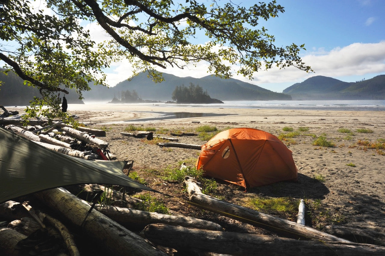
- Beach camps like Nels Bight and San Josef Bay can be wind-exposed; secure tents and gear accordingly.
Wildlife Awareness
- Northern Vancouver Island has healthy populations of black bears, coastal wolves, and cougars. Give wildlife space and keep food secured at all times.
- For paddlers, expect orcas, humpbacks, porpoises, and sea lions in Johnstone Strait and around Telegraph Cove. Maintain distance and avoid cutting across travel paths.
- Carry bear spray and know how to use it.
Weather & Seasonal Planning
- July and August offer the most reliable conditions for hiking and paddling, though rain is still common.
- May–June and September bring fewer crowds and more wildlife activity, but cooler nights and more storms.
- Fog is frequent along the north coast—plan extra time for slow driving and reduced visibility.
Connectivity & Services
- Cell service drops off quickly outside Port Hardy, Port McNeill, and Port Alice. Download offline maps before heading out.
- Bring cash for remote marinas, water taxis, or small campgrounds that may not accept cards.
- Stock up on groceries and supplies in Port McNeill or Port Hardy before venturing farther north.
Tips for Paddlers
- Check tides, swell forecasts, and wind—the north island coastline is exposed and can be challenging for inexperienced paddlers.
- Launch points like Telegraph Cove, Port Hardy, and Quatsino Sound offer more sheltered starts.
- Water is cold year-round; dry suits are recommended for open-coast routes.
Tips for Hikers
- Trails to Cape Scott and Nels Bight can be muddy and slippery, especially on boardwalk sections.
- Raft Cove’s trail is steep and rooty—good footwear is essential.
- San Josef Bay is family-friendly but still remote; bring all essentials.
What to Pack
- Waterproof layers and quick-dry clothing
- Extra food and water
- Water filter
- Bear spray
- Satellite communicator (InReach or Zoleo)
- Offline maps
- Spare tire and repair kit
- Cash for remote services
The opportunity for backcountry recreation on Vancouver Island is only limited by your imagination. The destinations are waiting. Are you ready? If you are planning a trip, check out our Vancouver Island North BC Recreation Map, our Vancouver Island BC Backroad Mapbook or our BRMB Maps app for iOS and Android, the ultimate resources for finding the best campsites as well as finding your way home again.