
Too big and bulky and
"Too big and bulky and the details are so small I can hardly read them. Would not buy again."


Couldn't load pickup availability
ISBN: 978-1-989175-04-0
UPC: 622098111200
Release: 2025
Edition: 3rd Edition
Dimensions: 86 x 117 cm (34 x 46.25 inches)
Map Scale: 2 sides @ 1:150,000
Double-Sided
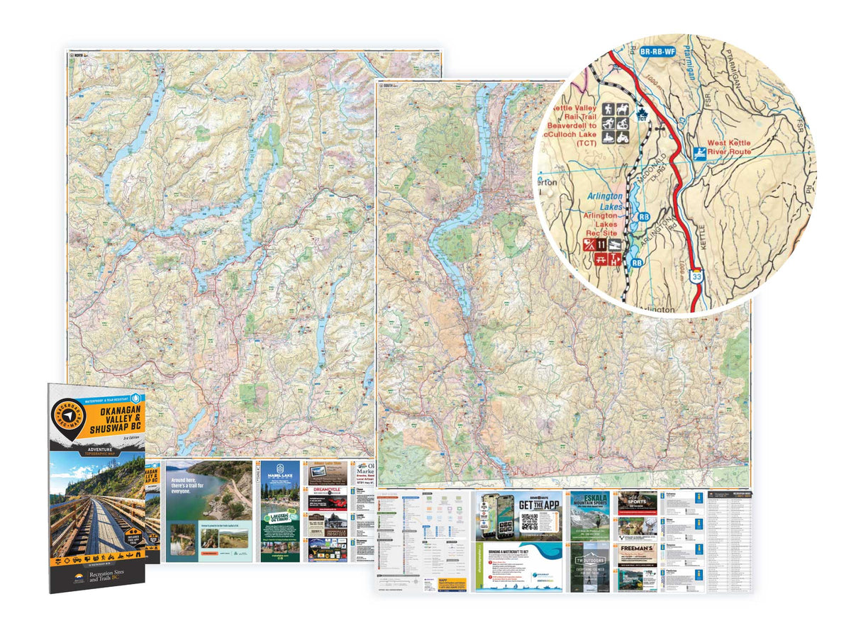
Okanagan Valley & Shuswap BC - Recreation Map
2 sides @ 1:150,000
Large Format
86 x 117 cm (34 x 46.25 inches)
Waterproof & Tear-Resistant
From the sun-soaked ridges of the South Okanagan to the snow-laden slopes of the Monashees, this map is made for those who don’t just pass through—they truly dig in. Designed with real use in mind and packed with intricate details, it’s your trusted companion for fishing alpine lakes, paddling pristine rivers, discovering remote recreation sites, or tearing through ATV and sled trails. Whether you’re hunting, camping, fishing, or blazing the backroads, this map has your back. No signal? No problem. Just unfold it and keep exploring.
MAP COVERAGE
From Adams Lake to Armstrong, Enderby to Grand Forks, and Kelowna to Naramata, this map spans Oliver, Osoyoos, Penticton, Salmon Arm, Seymour Arm, Sicamous, Vernon, and all the rugged backroads and untamed terrain connecting them.
Overall rating: 4.375 / 5 from 8 reviews.
Review topics: [].
"Too big and bulky and the details are so small I can hardly read them. Would not buy again."
"This map is a must for everyone who moves around in the interior of British Colombia"
"thanks for the new updated map"
"Great product. Easy to read, nice size ans waterproof!!"
"I was expecting something smaller that I could carry with me, instead I’ll frame it and hang on my wall."
"Some of us - dare I say, are old school and still relish the tactile and visual effect of a literal map rather than a digital one. The quality of the material and calibre of detail is well worth the price point."
"Haven’t had an opportunity to fully explore, but looks excellent, like all your products!"
"I haven’t used it yet, I’m waiting for my bike rack for my car to come in. The map is very detailed, someone or group of people went to a lot of work putting this together."

Overlanding in BC means driving the province's enormous network of forest service and resource roads to reach free Crown-land camping most people never see. Roughly 58,000 km of forest service...

Where the rugged peaks of the Coast Mountains meet the waters of the Harrison and Fraser rivers, the Harrison River Valley offers some of British Columbia's most diverse outdoor experiences....

Home to vineyards, orchards, small farms and endless outdoor adventure, the Naramata Bench along the eastern shore of Okanagan Lake is one of British Columbia's must-visit destinations. While it's best...

Finding legal places to ride an ATV in Canada comes down to three things: a trail network, Crown land where off-road vehicles are allowed, and the right permit, registration, and...

Canadian residents can camp free on most Ontario Crown land for up to 21 days, no fee and no reservation. Here are the rules, the best regions to head to,...

The Kamloops region is one of the best stillwater trout fisheries on earth, with hundreds of stocked lakes within a short drive. Here are the top lakes to fish this...

Crown land covers about 94% of British Columbia, and most of it is open for free camping. Here is how the rules work, the best regions to head to, how...

Many anglers overlook Saskatchewan, assuming it’s nothing but prairie, but they’re missing out on some truly exceptional fishing. The province is home to more than 100,000 lakes, a fact that...

Scale
Area
Dimensions
Pages
Release
Features