

Best Fishing Lakes Near Kamloops, BC: A Trout Angler's Guide (2026)
The Kamloops region is one of the best stillwater trout fisheries on earth, with hundreds of stocked lakes within a short drive. Here are the top lakes to fish this...


Couldn't load pickup availability
ISBN: Not available
UPC: 622098111729
Release: 2025
Edition: 2nd Edition
Dimensions: 5x8.25 inches (folded) / 27.8×39.4 inches (unfolded)
Map Scale: 1:58,000 Scale
Double-Sided
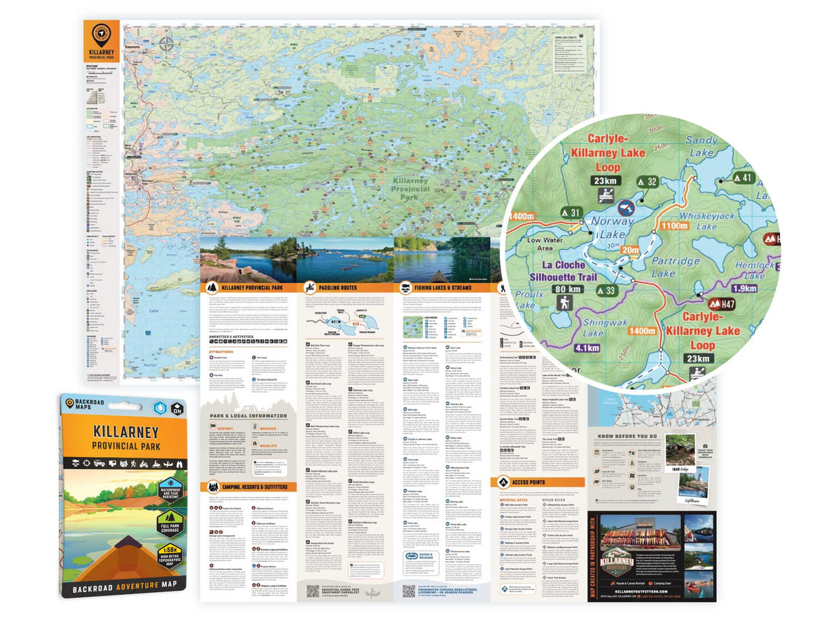
Killarney Provincial Park Ontario - Park Map
1:58,000 Scale
Large Format
5x8.25 inches (folded) / 27.8×39.4 inches (unfolded)
Waterproof & Tear-Resistant
Covering Killarney Provincial Park in Northern Ontario, this map features the hiking trails, canoe routes, access points, campsites, lakes and visitor facilities. This Adventure map includes 1:10,000 water and trail data and can be used for hiking, canoeing, camping, exploring, fishing, kayaking, skiing, wildlife viewing and more!
Covering 640 sq. km (247 sq. mi), this map includes Killarney Provincial Park, Killarney, Baie Fine, Bell Lake, Crooked Lake, George Lake Campground, Johnnie Lake, Kakakise Lake, La Cloche Mountains, La Cloche-Silhouette Trail, Lake Panache, Nellie Lake, Osa Lake, Threenarrows Lake and more!
The printed version of the map is displayed at 1:58,000 scale on 5x8.25 inches (folded) / 27.8×39.4 inches (unfolded) paper on a durable waterproof synthetic material.

Crown land covers about 94% of British Columbia, and most of it is open for free camping. Here is how the rules work, the best regions to head to, how...

Many anglers overlook Saskatchewan, assuming it’s nothing but prairie, but they’re missing out on some truly exceptional fishing. The province is home to more than 100,000 lakes, a fact that...

From remote wilderness and scenic waterways to unique geological formations and abundant wildlife, Saskatchewan is full of “hidden gems” waiting to be discovered.

Summary: This guide covers everything BC spring bear hunters need for 2026: when seasons open across key WMUs, which regions; Cariboo, Thompson, Fraser Valley, hold the best opportunity, how to...

Did you know 89% of Canada is crown land, and most of it is free to camp on? No reservations, no fees, no crowded campgrounds. But knowing where you're allowed...

From Cape Scott to Strathcona and the Broughton Archipelago, discover the best Northern Vancouver Island provincial parks for backcountry hiking, camping and sea kayaking.

Looking for the best Northern Vancouver Island camping? This guide covers top BC Recreation Sites and Forest Service campsites near Port McNeill, Gold River, Port Hardy and Campbell River, including...

Scale
Area
Dimensions
Pages
Release
Features