
July 23, 2026
Overlanding in British Columbia: Best Backroad Routes & How to Do It Right (2026 Guide)
Overlanding in BC means driving the province's enormous network of forest service and resource roads to reach free Crown-land camping mos...



Couldn't load pickup availability
Map Scale: Created at
Note: In case of multiple options, the actual map scale will vary depending on the wall map size you choose.
Dimensions: 61 x 94 cm/24 x 37 inches
This map includes
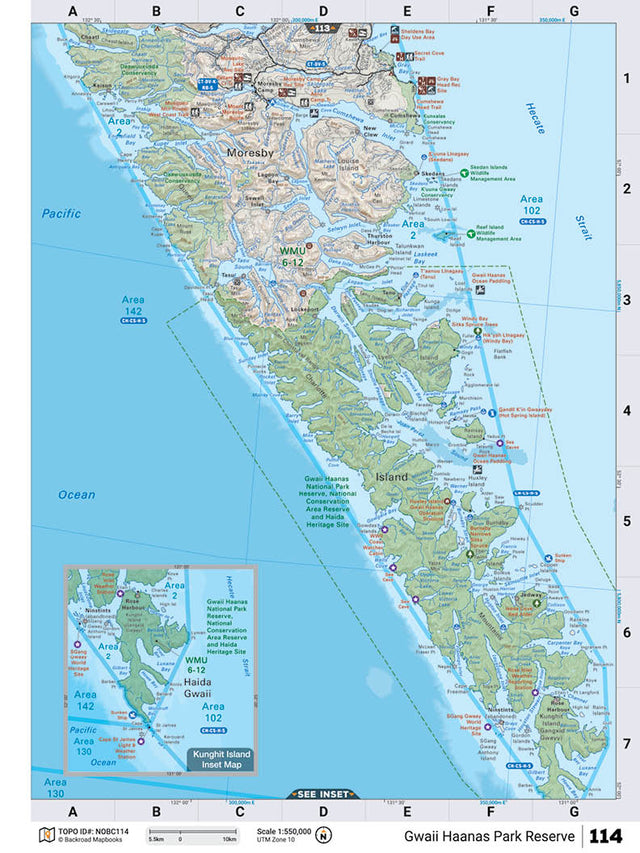
This recreation map for the Gwaii Haanas Park Reserve area highlights all the logging and resource roads, recreational features and trails for hiking, mountain biking, ATVing, snowmobiling, skiing, snowshoeing, fishing, camping, hunting, canoeing, kayaking, wildlife viewing and more. New features include private land and labelled fish species, plus new roads, recreational trails and Points of Interest. No other map for the area provides you with this level of recreational or topographic detail. Measuring 105 x 140 km (65 x 87 mi), this 1:185,000 scale map covers 14,750 km2 (5,695 mi2) in total and includes Moresby Island, Lagoon Bay, Rose Harbour, Gwaii Hanaas National Park Reserve, Tanu, Jedway, Mosquito Lake, Thurston Harbour, New Clew, Cheatl and more! This map also covers the following Wildlife Management Units: WMU 6-12 Skeena, WMU 6-13 Skeena. Gwaii Haanas Park Reserve - Northern BC is printed on demand at our office in Coquitlam (BC) and measures 61 x 94 cm (24 x 37 inches).
Want the whole book?
Get the whole book in one easily downloadable format from here: Shop Map Bundles
Only interested in one or two maps?
Get the individual TOPO PDF Maps from here: Shop Individual Maps

The TOPO Maps series lets you select any map from our Backroad Mapbooks collection, enlarged for a clearer and more detailed view of your area. These High-Detail Maps feature industry-leading topographic relief, making them ideal for your hunting, paddling, hiking, or camping trips.
Each map measures 24” by 37” flat and folds to a compact 4.25” by 9.25”. Printed on a waterproof synthetic material for extra durability.
Starting at 1:50,000 scale with shaded relief and contour lines. Features UTM and Latitude/Longitude grid, along with a map location grid and scale bar for easy and accurate navigation.
Customizable map areas are available by request: contact us for special TOPO requests such as custom map areas, adding features or other customization requests at info@backroadmapbooks.com
Showing articles tagged “British Columbia”
July 23, 2026


June 19, 2026


March 04, 2026
Scale
Area
Dimensions
Pages
Release
Features