Double-Sided
New Edition

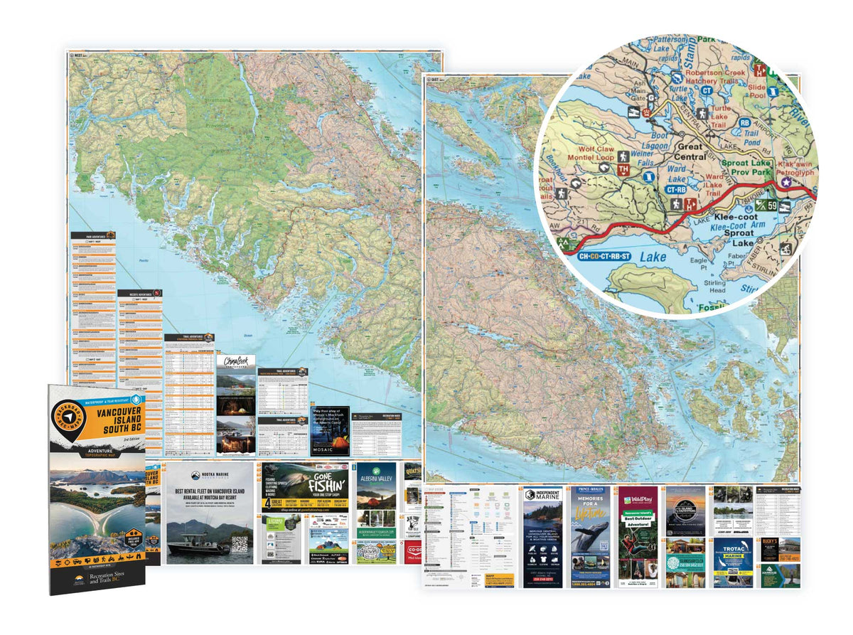
Vancouver Island South BC - Recreation Map

Vancouver Island BC 💧 Waterproof Map
Write a review
$2500

 More payment options

Pickup available at Backroad Maps Head Office

Usually ready in 24 hours

Barcode: 6-22098-11121-7

Specs

Map Scale: 2 sides @ 1:180,000
Release:
2025 3rd Edition
Dimensions: 86 x 117 cm (34 x 46.25 inches)

Double-Sided

Area Covered

Bamfield, Comox, Courtenay, Cumberland, Duncan, Gold River, Ladysmith, Lake Cowichan, Nanaimo, Pacific Rim National Park, Parksville, Port Alberni, Port Renfrew, Qualicum Beach, Sidney, Sooke, Strathcona Park, Tofino, Ucluelet, Victoria and more

Map Features

Highways, Logging Roads, Land & Water Features, Parks, Adventure Points of Interest, Campgrounds, Hiking Trails, Motorized Trails, Paddling Routes, Hunting & Fishing Areas, Winter Recreation and More

2 sides @ 1:180,000

Large Area Coverage: ideal to plan your road-trips, find RV & tent campsites, explore rec & service roads, and more!

Large Format

86 x 117 cm (34 x 46.25 inches)
Waterproof & Tear-Resistant

Description

Navigating the Wild

From the surf of Tofino to the snowy peaks of Mount Washington, this map is crafted for those who venture beyond the pavement. It’s your ultimate guide to the real island: where the roads get rough, the cell signal fades, and the adventure truly begins. Navigate wild coastlines, trek deep into lush rainforests, fish tranquil stocked lakes, or carve through remote ATV and snowmobile trails. 100% waterproof and tear-resistant, this map is built to endure every challenge. Whether you’re ATVing, fishing, hunting, paddling, tracking wildlife, or uncovering that hidden campsite, this map has you covered.

  • Unstoppable Durability: Waterproof, tear-resistant, and ready to tackle rain, mud, snow, and rugged use.

  • Rich in Detail: Includes trails, logging roads, stocked lakes, campgrounds, WMUs, and prime fishing spots.

  • GPS-Compatible: Seamlessly integrates with GPS devices and mobile apps for reliable navigation.

MAP COVERAGE
Covering Courtenay, Comox, Tofino, Port Alberni, Parksville, Nanaimo, Lake Cowichan, Duncan, Bamfield, Victoria, the Gulf Islands, and every backroad in between, this map ensures you're prepared for any adventure on Vancouver Island and beyond.
In Partnership With BC Recreation Sites & Trails

Recreation Sites and Trails B.C. (RSTBC) provides public recreation opportunities by developing, maintaining and managing a network of recreation sites and recreation trails throughout British Columbia.

Learn more:

https://www2.gov.bc.ca/gov/content/sports-culture/recreation/camping-hiking/sites-trails

Customer Reviews

We’re looking for stars!
Let us know what you think

Vancouver Island South BC - Recreation Map

$2500
Navigating the Wild From the surf of Tofino to the snowy peaks of Mount Washington, this map is crafted for those who venture beyond the pavement. It’s your ultimate guide to the real island: where the roads get rough, the cell signal fades, and the adventure truly begins. Navigate wild...

Scale

2 sides @ 1:180,000

Area

Bamfield, Comox, Courtenay, Cumberland, Duncan, Gold River, Ladysmith, Lake Cowichan, Nanaimo, Pacific Rim National Park, Parksville, Port Alberni, Port Renfrew, Qualicum Beach, Sidney, Sooke, Strathcona Park, Tofino, Ucluelet, Victoria and more

Dimensions

86 x 117 cm (34 x 46.25 inches)

Pages

2

Release

2025

Features

Highways, Logging Roads, Land & Water Features, Parks, Adventure Points of Interest, Campgrounds, Hiking Trails, Motorized Trails, Paddling Routes, Hunting & Fishing Areas, Winter Recreation and More
View product