Looking for the best BRMB map for your next outdoor adventure? Whether you're paddling remote lakes, off-roading into the backcountry, or hiking a rugged trail, choosing the proper map format depends on how much detail and coverage you need. This guide breaks down the differences between all our map series so that you can pick the perfect one with confidence.
This guide will help you understand the key differences between our map series, including size, format, scale, coverage, and how to get even more from your maps with the BRMB App.
Map Sizes & Format: What's the Difference?
Not all maps are built the same, and that’s a good thing. Depending on how much ground you plan to cover (and how much detail you need), different formats serve different purposes.

| Map Series | Size | Scale | Best For |
|---|---|---|---|
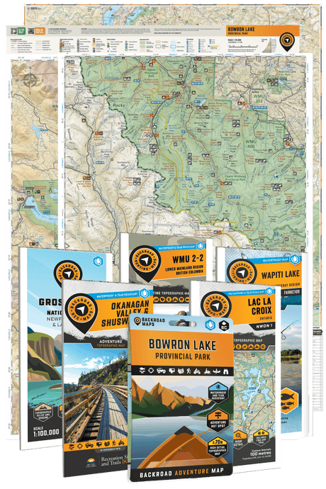
| Recreation Maps | 34" x 46.25" Double-Sided (2 full maps) |
1:140K-200K | Big regional adventures, road trips, ATV routes, fishing & camping |
| 2025 Park & Destination Maps | 27.8" x 39.4" Double-Sided (Map + Info) |
1:42K-150K | Detailed navigation within specific parks & wilderness areas |
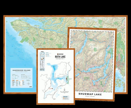
| Other Park & Destination Maps (Print-on-Demand) | 24" x 36" Single-Sided |
1:15K-225K | Moderate-detail maps for popular parks and hotspots |
| Topo Maps (Print-on-Demand) |
24" x 36" Single-Sided |
1:50K-200K | High-detail navigation in small, remote areas |
| Hunting TOPO Maps (Print-on-Demand) |
24" x 36" Single-Sided |
1:50K-200K | High-detail navigation for hunting areas |
| Fishing Charts (Print-on-Demand) |
24" x 36" Single-Sided |
n/a | High-detail bathymetry (depth) charts of fishing lakes |
Each of these mapbook regions is mirrored on the BC trail adventures, so you can preview the coverage area before placing an order.
Understanding Map Scale
Map scale tells you how much real-world distance is represented by a measurement on the map. It affects how much detail is shown—and how much ground you can “see” at once.
🔍 Two Common Scales We Use:
-
1:150,000 scale
- 1 cm = 1.5 km on the ground
- Best for broad regional navigation, perfect for road trips and 4wd routes, finding campsites, or getting the big picture of a whole area.
-
1:50,000 scale
- 1 cm = 500 m on the ground
- Ideal for precise navigation, such as finding trail junctions, paddling portages, or scouting off-grid campsites.

Want the best of both worlds?
Use your printed map alongside the BRMB App for even more detail and live location tracking. The app lets you zoom in on terrain, trails, and access points, while your paper map provides the full area context, especially handy when you're off the grid.
Which Folded Maps Are Available in Each Province?
Here's how each map series covers different regions, and where they’re available:
🛻 Recreation Maps
- Provinces: British Columbia (most major areas) & Ontario (currently: Algonquin Park region)
- Coverage: Large areas—think entire valleys, coastlines, or networks of forest service roads.
- Great for: ATVing and off-roading, road trips and RV camping, multi-lake fishing missions, and exploring backroad networks.
🏕️ 2025 Park & Destination Maps
- Provinces: British Columbia (Bowron Lake, Strathcona, Tweedsmuir) & Ontario (Kawartha Highlands, Killarney)
- Coverage: Medium-sized areas focused on individual parks or adventure hot spots
- Great For: Hiking trails & route planning, paddling & portaging, wildlife viewing & photography, and backcountry camping
🏕️ Other Park & Destination Maps (Print-on-Demand)
- Provinces: BC, Alberta, Ontario, Atlantic Canada, and Washington State (US)
- Coverage: Medium-sized areas focused on individual parks or adventure hot spots
- Great For: Hiking trails & route planning, paddling & portaging, wildlife viewing & photography, and backcountry camping
🥾 TOPO Maps (Print-on-Demand)
- Provinces: All Canadian Provinces (except Quebec)
- Coverage: Small, localized areas—ideal for remote or off-grid zones
-
Great For: Backpacking into crown land, precise route mapping, hunting, fishing, and elevation-focused navigation, and any areas not covered by other maps
🦌 Hunting Maps (Print-on-Demand)
- Provinces: British Columbia, Alberta, and Ontario
- Coverage: Small hunting areas
- Great For: Wildlife Management Units, Game Hunting Areas, and both crown and private lands.
🎣 Fishing Charts (Print-on-Demand)
- Provinces: British Columbia
- Coverage: Bathymetry (depth) charts of the top fishing lakes in BC
- Great For: Finding the best fishing lakes and rivers for each region. Includes nearby roads and trails, boat launches and access points, fishing docks, campsites and resorts.
The same lake-level fishing detail flows into the BC paddling adventures, so you can preview a lake's species and stocking history before deciding if you need the print chart.
The full regional breakdown is mirrored in the Northwest Territories backcountry coverage, using the same regional grouping as the print catalog.
Features You’ll Find on Every Map
Backroad Maps is Canada’s most detailed and comprehensive outdoor map publisher, and every map we make reflects that level of detail and durability. No matter which format you choose, every BRMB map is built to last and packed with Canada’s most comprehensive outdoor details. Here’s what you can count on:
-
Waterproof & Tear-Resistant:
Made to handle everything from sideways rain to muddy gloveboxes to snow-covered packs.
-
All the Adventures in One Map:
We include more than any other map, period. Trails, logging roads, campgrounds, stocked lakes, fish species, WMUs, crown land, paddle routes, trailheads, and more. You’ll never look at another map the same way.
-
Proudly Designed in Canada:
Created by outdoor explorers who know this terrain inside and out.