

How to Install GPS Maps: Digital Download vs Plug & Play microSD Cards
Learn how to install Backroad GPS Maps using a Plug & Play microSD card or digital download. Compare formats, compatibility, and setup steps.


Couldn't load pickup availability
PLUG & PLAY MicroSD Card
DIGITAL LICENSE
Scale: Dynamic Scale
Version:
Covering these GPS Maps are the most detailed, comprehensive and up-to-date GPS maps available on the market.
Keep your adventure rolling with the latest topographic data, routable roads, oil and gas data, Wildlife Management Units, trails, rec sites, paddling routes, scenic viewpoints and so much more. With the latest edition of our Washington State GPS Maps GPS Maps in hand, your options for adventure are limitless.
Our Backroad GPS Maps are designed to be compatible with most Garmin GPS Vehicle or Outdoor models made in 2012 and later that accept SD or Micro-SD cards.
However, it’s important to note that some units may experience issues with display or feature availability, depending on the model version.
You can check if your unit is compatible here.
Includes a Free One-Year Pro Subscription to the BRMB Maps smartphone App and Web Map.
PLUG & PLAY SD CARD
DIGITAL LICENSE
Situated at the northwest corner of the continental United States, Washington State is a land of unparalleled beauty, where rainforest-clad mountains tower over the wild Pacific coast and vast stretches of undeveloped wilderness provide the perfect backdrop for endless outdoor adventures. Whether you are traveling a highway, hiking trail or forest service road, Backroad Mapbooks Washington GPS Maps are your ultimate tool for navigating the Evergreen State. These Garmin-licensed GPS Maps feature easy-to-read elevation contours and reveal all the natural features such as creeks, wetlands and glaciers, plus every road and trail that is left off of other maps. Ten categories of Adventure Points of Interest guide you to the best outdoor recreation sites Washington State has to offer, whether you are day hiking from Seattle or backcountry hunting, fishing, paddling, ATVing, snowmobiling and more. From the Olympic Peninsula to the Cascade Mountains, down to the Columbia River basin and back up to the San Juan Islands, Backroad Mapbook GPS Maps provide an impressive level of detail and adventure information.
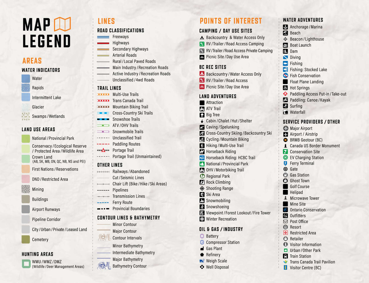
Unique to the Washington State GPS Maps are our Custom or Backroad POI sets. Within Washington we have over 43,000 searchable points including resource facilities, transportation services, historic sites, viewpoints, waterfalls, hot springs and more. Backroad POIs can be searched by selecting the Where To/Find > Extras and then Go! option, or read what each site offers through the More option. This added feature to our GPS Maps gives you the descriptions or write-ups of most recreation sites in the style of our popular Backroad Mapbook guidebook series. Note: Public Land Survey System sections (PLSS) can be searched by selecting Where To/Find > Cities and then by entering the Township & Range grid reference for each section. For Washington State sections, enter the PLSS grid number (ex: TO1N R02E Sec01).
Backroad Extras
Backroad Extras are where you find all the POI information specific to our Backroad GPS Maps.
Backroad Mapbooks’ Garmin-licensed Washington State GPS Maps are the most detailed, comprehensive and up-to-date recreation GPS maps available on the market. These are the maps of choice for serious outdoor explorers, with 3D views, shaded relief and countless geographic and activity based points-of-interest. Compatible with Garmin GPS and Garmin Basecamp, BRMB’s Washington State GPS Maps come in Micro SD format and are easy to install and use, bringing the height of cartographic sophistication and outdoor recreation information directly to your GPS device or computer. Keep your adventure rolling with the latest topographic data, routable and non-routable roads, multi-use trails, Game Management Units, campgrounds, national and state parks and so much more. With the brand new Washington State GPS Maps in hand, your options for adventure are limitless.
Unique to BRMB’s GPS Maps are written Adventure descriptions compiled by our team of outdoor writers and researchers. Descriptions fill you in on information including trail distance and elevation gain, fish species and stocking information, directions to staging areas for ATV and snowmobile, amenities and activities for national and state parks, campground size and reservation information, difficulty of paddling routes, game hunting species and much more.
Search highly descriptive point of interest and recreation site write ups in the style of our popular Backroad Mapbook guide book series.
Note: Backroad Extras or Points of Interest can be searched by selecting the Where To/Find > Extras and then Go! option, or read what each site offers through the More option.
Unique to the Backroad GPS Maps are our enhanced road classifications that help you distinguish the highways from the forest roads and the main roads from the side roads. This extra level of road classification, along with routing ability, helps you to know which roads can be driven in a car and which ones should be left to a four-wheel drive vehicle or ATV.
In addition, we offer more recreational points and symbols than any other map source. From RV accessible to backcountry campsites, hiking to snowmobiling trailheads, fishing to paddling access points, we have your adventure covered.
Washington State Road and Trail Highlights:
Learn how to install Backroad GPS Maps using a Plug & Play microSD card or digital download. Compare formats, compatibility, and setup steps.

Choosing the right Garmin GPS device can make all the difference when you're exploring remote routes and navigating unfamiliar terrain. With so many models available, each designed for different purposes...

How We Determine Compatibility Our are designed to be compatible with most Garmin GPS units that support microSD cards. However, it’s important to note that some units may experience issues...

Why should I update? Upgrades may include new land classifications, extra road and trail coverage, new Adventure POIs, and more. Whether you are hunting, fishing, camping, hiking, paddling, exploring forest...

Why should I register my GPS Maps? Here's a few benefits you get from Registering: Download Computer Maps for Garmin Basecamp Store a secure copy of your Garmin License and...

What's New in V2025? All Version 2025 GPS Maps feature new and improved roadways, off-road trails, and highway points of interest, making trip planning and navigation easier. Key updates include:...

British Columbia – VERSION 2025 Release date: November 2024 Shop GPS Maps Update your Maps General Enhanced Road Enhanced ATV, Snowmobile, Multi-use Trail, Paddling and TCT data New Dirtbike New...

Alberta – VERSION 2025 Release Date: November 2024 Shop GPS Maps Update your Maps General Enhanced Road Enhanced Road Names Enhanced ATV, Snowmobile, Multi-use Trail, Paddling and TCT data New...

Scale
Area
Dimensions
Pages
Release
Features
Type
Format