Backroad GPS Maps & Garmin Devices Compatibility
How We Determine Compatibility Our are designed to be compatible with most Garmin GPS units that support microSD cards. However, it’s important to note that some units may experience...
Couldn't load pickup availability
PLUG & PLAY MicroSD Card
DIGITAL LICENSE
Scale: Dynamic Scale
Version:
Covering these GPS Maps are the most detailed, comprehensive and up-to-date GPS maps available on the market.
Keep your adventure rolling with the latest topographic data, routable roads, oil and gas data, Wildlife Management Units, trails, rec sites, paddling routes, scenic viewpoints and so much more. With the latest edition of our Manitoba GPS Maps GPS Maps in hand, your options for adventure are limitless.
Our Backroad GPS Maps are designed to be compatible with most Garmin GPS Vehicle or Outdoor models made in 2012 and later that accept SD or Micro-SD cards.
However, it’s important to note that some units may experience issues with display or feature availability, depending on the model version.
You can check if your unit is compatible here.
Includes a Free One-Year Pro Subscription to the BRMB Maps smartphone App and Web Map.
PLUG & PLAY SD CARD
DIGITAL LICENSE
Located in the Canada’s geographic center, Manitoba boasts a vast and wild landscape that is brimming with outdoor recreation opportunities. Over half of the province’s population lives in the capital city of Winnipeg, leaving the rest of Manitoba wide open for outdoor explorers. From the rolling prairie to the sprawling pine forest, ancient Canadian shield rock and Arctic tundra, there is much to discover here, whether on foot, by car, bicycle, ATV, snowmobile or kayak. And don’t forget the approximately 100,000 lakes that offer anglers some of the most exciting fishing action in the country, nor the abundant hunting ranges for everything from Canada goose to white-tailed deer.
Point of Interest (POI)
Unique to BRMB’s Manitoba GPS Maps are feature POI sets of close to 200,000 searchable points including Oil and Gas Township Quarter Section Grid locations, Resource Facilities and Backroad POI sets.
Note: Backroad POIs can be searched by selecting the Where To/Find > Extras and then Go! option, or read what each site offers through the More option.
Oil and Gas Resource Facilities can be searched by selecting Where To/Find > Cities and then by entering the full Grid reference for Facilities. For Manitoba facilities enter the Township Quarter Section Grid Reference (ex: NE-07-124-23-3, SE-27-24-15-W).
Manitoba Custom POI Highlights
Manitoba Categories:
Backroad Mapbooks’ industry-leading, Garmin-licensed Manitoba GPS Maps are the most detailed, comprehensive and up-to-date GPS maps available on the market. These are the maps of choice for recreation, industry, and search-and-rescue, with 3D views, shaded relief and countless geographic and activity based points-of-interest. Updated annually, these GPS maps are Garmin licensed for compatibility with Garmin GPS and Garmin Basecamp. Available in Micro SD format, these Manitoba GPS Maps are easy to install and use and bring you all of the detail of our wildly popular Backroad Mapbook series directly to your GPS device or computer. Keep your adventure rolling with the latest topographic data, routable roads, oil and gas data, Game Hunting Areas, trails, rec sites, paddling routes, scenic viewpoints and so much more. With the latest edition of our Manitoba GPS Maps in hand, your options for adventure are limitless.
Manitoba Backroad GPS Map Features
Explore More by Using the Search Function
Search highly descriptive point of interest and recreation site write ups geo-referenced from our popular Backroad Mapbook guide book series.
Note: Backroad Extras or Points of Interest can be searched by selecting the Where To/Find > Extras and then Go! option, or read what each site offers through the More option.
Unique Road Classifications
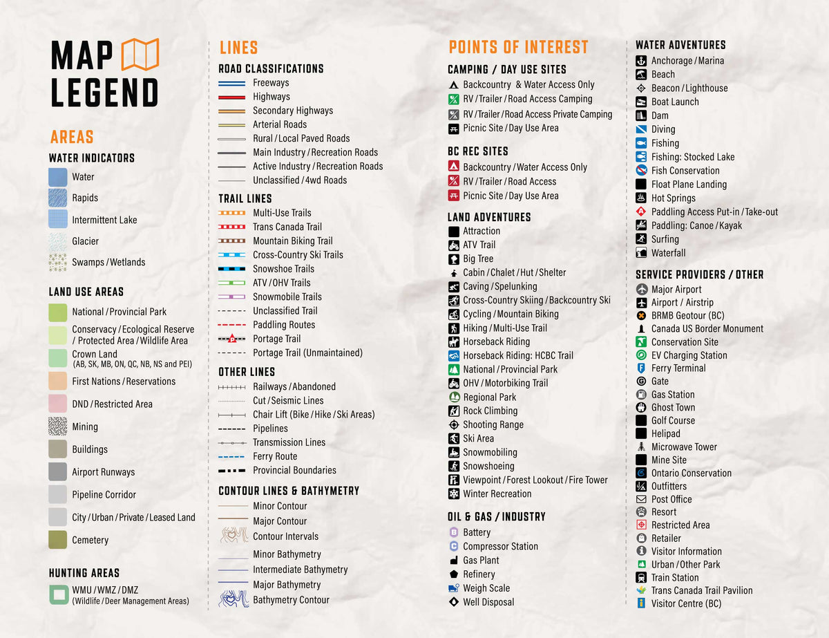
Unique to the Backroad GPS Maps are our enhanced road classifications that help you distinguish the highways from the logging roads and the main roads from the side roads. This extra level of road classification helps you to know which roads can be driven in a car and which ones should be left to a four-wheel drive vehicle or ATV.
In addition, we offer more recreational points and symbols than any other map source. From RV accessible to backcountry campsites, hiking to snowmobiling trailheads, fishing to paddling access points, we have your adventure covered. Our area classifications include mines and gravel pits, conservation and restricted areas, and a host of other features that help you to see where you can play.
Get More Roads and Trails
Boasting more roads and trails than any other GPS maps, our road tracking classifications allow you to easily distinguish main industrial or logging roads from rarely travelled unclassified roads. Access over 92,500 km of routable city and rural roads, with 3 levels of industry roads (forest service, resource and recreational) along with close to 50,000 km of non-routable roads including unclassified and private roads. Close to 2,500 km of multi-use trails are separated for use by hikers, bikers and horseback riders, along with over 16,000 km of ATV and Snowmobile motorized trails. Trails are updated and expanded with the help of government agencies, off-road clubs and customers who contribute their own data.
Manitoba Road and Trail Highlights:
