Killarney Provincial Park Ontario - Park Map
Northeastern Ontario 💧 Waterproof Map
Pickup available at Backroad Maps Head Office
Usually ready in 24 hours
Specs
Specs
Map Scale: 1:58,000 Scale
Release: 2025
Dimensions: 5x8.25 inches (folded) / 27.8×39.4 inches (unfolded)
Double-Sided
Area Covered
Area Covered
Map Features
Map Features

Killarney Provincial Park Ontario - Park Map
1:58,000 Scale
Large Format
5x8.25 inches (folded) / 27.8×39.4 inches (unfolded)
Waterproof & Tear-Resistant
Description
Description
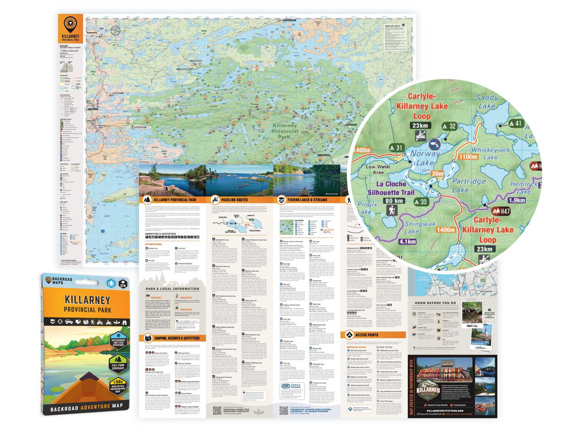
Covering Killarney Provincial Park in Northern Ontario, this map features the hiking trails, canoe routes, access points, campsites, lakes and visitor facilities. This Adventure map includes 1:10,000 water and trail data and can be used for hiking, canoeing, camping, exploring, fishing, kayaking, skiing, wildlife viewing and more!
Covering 640 sq. km (247 sq. mi), this map includes Killarney Provincial Park, Killarney, Baie Fine, Bell Lake, Crooked Lake, George Lake Campground, Johnnie Lake, Kakakise Lake, La Cloche Mountains, La Cloche-Silhouette Trail, Lake Panache, Nellie Lake, Osa Lake, Threenarrows Lake and more!
The printed version of the map is displayed at 1:58,000 scale on 5x8.25 inches (folded) / 27.8×39.4 inches (unfolded) paper on a durable waterproof synthetic material.
Print Features:
-
NEW: Now in an easy-to-read, bigger format, 5x8.25 inches (folded) / 27.8×39.4 inches (unfolded)
- NEW: In addition to the maps, we have included several trip planning sections with information about the park, camping, resorts, outfitters, paddling routes, fishing lakes & streams, hiking & multi-use trails, access points and tips & techniques.
- Printed on durable waterproof, and tear-resistant material
- Includes industry-leading cartographic detail and state-of-the-art relief shading
- Countless points of interest, hiking trails, campsites, boat launches, paddling routes and more!

In Partnership With Killarney Outfitters