Unlock the Outdoors with 25% Off! Ends December 2nd, 2024

Vancouver Island South BC - Recreation Map

Vancouver Island BC 💧 Waterproof Map
$1695 $1995

Barcode: 6-22098-11005-0

Specs

Map Scale: 2 sides @ 1:180,000
Release:
2021
Dimensions: 86 x 117 cm (34 x 46.25 inches)

Area Covered

Bamfield, Comox, Courtenay, Cumberland, Duncan, Gold River, Ladysmith, Lake Cowichan, Nanaimo, Pacific Rim National Park, Parksville, Port Alberni, Port Renfrew, Qualicum Beach, Sidney, Sooke, Strathcona Park, Tofino, Ucluelet, Victoria and more

Map Features

Highways, Logging Roads, Land & Water Features, Parks, Adventure Points of Interest, Campgrounds, Hiking Trails, Motorized Trails, Paddling Routes, Hunting & Fishing Areas, Winter Recreation and More

Description

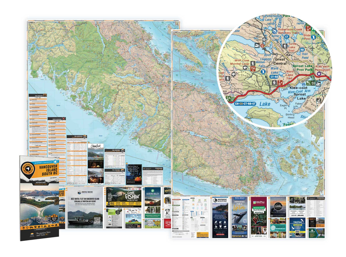
VANCOUVER ISLAND BC SOUTH WATERPROOF ADVENTURE MAP

From the breathtaking wilderness of Strathcona Provincial Park to the historic Victoria waterfront, Southern Vancouver Island is a land of diverse recreational opportunity. In the north of the area covered by this map, Mount Washington offers world-class skiing, snowboarding and mountain biking. To the west, Tofino is a surfer’s paradise, widely regarded for having the best waves in Canada. The vibrant rainforests of Pacific Rim National Park offer stunning hiking and camping, while the many small towns that dot the Island’s coast are hot-spots for fishing and whale-watching. Found in the southeast section of this map, the Gulf Islands are one of Canada’s hidden treasures and the perfect place to slow things down and get lost for a little while. Taking in everything Southern Vancouver Island has to offer is impossible, but this map will certainly get you started on the right track.

To help you discover the best of Southern Vancouver Island, the BRMB team has worked tirelessly to create the most comprehensive, detailed and easy to use map for Southern Vancouver Island you will find anywhere. This dual sided 34” x 46.25” map is printed on durable, waterproof paper to withstand anything Mother Nature throws at you. With industry-leading cartographic detail, sate-of-the-art relief shading, UTM and longitude/latitude grid, colour coded Provincial Parks, Wildlife Management Units, Recreation Sites and more, you can stay focused on your adventure and not on trying to decipher a hard-to-read map. This map is jam-packed with points of interest, hiking trails, campsites, paddling routes and more, so no matter what your favourite outdoor activity is, we’ve got you covered. This map also features detailed descriptions of recreation sites and parks with information on camping, fees, activities, access and more. Covering the areas around Duncan, Tofino, Bamfield, Victoria, the Gulf Islands and more, this is a must-have for any Vancouver Island adventure.

Looking for a different area?

Browse our TOPO Maps: Zoom into your province to see the map grid, then click on any of the highlighted areas to select your TOPO Map

Vancouver Island South BC - Waterproof Recreation Map - Recreation Map

Vancouver Island South BC - Recreation Map

$1695 $1995
VANCOUVER ISLAND BC SOUTH WATERPROOF ADVENTURE MAP From the breathtaking wilderness of Strathcona Provincial Park to the historic Victoria waterfront, Southern Vancouver Island is a land of diverse recreational opportunity. In the north of the area covered by this map, Mount Washington offers world-class skiing, snowboarding and mountain biking. To...

Scale

2 sides @ 1:180,000

Area

Bamfield, Comox, Courtenay, Cumberland, Duncan, Gold River, Ladysmith, Lake Cowichan, Nanaimo, Pacific Rim National Park, Parksville, Port Alberni, Port Renfrew, Qualicum Beach, Sidney, Sooke, Strathcona Park, Tofino, Ucluelet, Victoria and more

Dimensions

86 x 117 cm (34 x 46.25 inches)

Pages

2

Release

2021

Features

Highways, Logging Roads, Land & Water Features, Parks, Adventure Points of Interest, Campgrounds, Hiking Trails, Motorized Trails, Paddling Routes, Hunting & Fishing Areas, Winter Recreation and More
View product