Point Pelee National Park ON - Wall Map
Southern Ontario
Couldn't load pickup availability
Scale & Dimensions
Scale & Dimensions
Map Scale: Created at
Note: In case of multiple options, the actual map scale will vary depending on the wall map size you choose.
Dimensions: 3 Options Available
Area Covered
Area Covered
This map includes
Map Features
Map Features

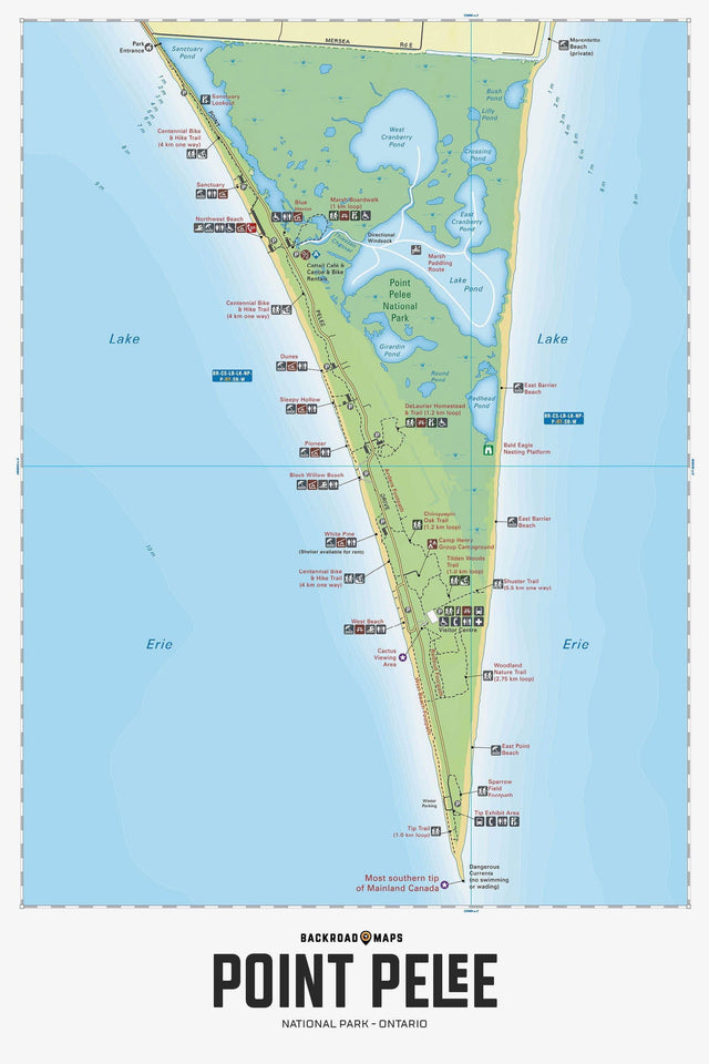
Discover Point Pelee National Park in Southwestern Ontario like never before. This map covers the southernmost point in Canada, a unique ecologically diverse area that is home to thousands of migratory birds each spring and fall, Monarch butterflies in fall and wonderful beaches to enjoy in summer. Large, protected ponds and marshes, along with the open expanse of Lake Erie invite paddlers, while an impressive trail system allows hikers, cyclists and walkers to explore the area from tip to tail. This recreation map also features the many picnic and day-use areas, birdwatching areas, interpretive trails, canoeing and kayaking routes, trails with distances included, wildlife viewing areas and more. The highly detailed map uses 1:10,000 water and trail data and showcases all the amenities and recreational opportunities available in the park. This map includes Point Pelee National Park, Black Willow Beach, Camp Henry, DeLaurie Homestead, East Beach, Lake Erie, Lake Pond, Sanctuary Pond, West Beach, West Cranberry Pond and White Pine in Essex County of Southwestern Ontario.
The Wall Map Format
The Wall Map version of this map features a minimal layout to display nicely to fit into common picture frame sizes so you can hang it on the cabin, home or workshop wall.
All maps come printed on waterproof synthetic material for extra durability.