

Free Camping in BC: Recreation Sites, Crown Land & How to Find It (2026)
Crown land covers about 94% of British Columbia, and most of it is open for free camping. Here is how the rules work, the best regions to head to, how...


Couldn't load pickup availability
ISBN: Not available
UPC: 622098111712
Release: 2025
Edition: 2nd Edition
Dimensions: 5x8.25 inches (folded) / 27.8×39.4 inches (unfolded)
Map Scale: 1:42,000 Scale
Double-Sided
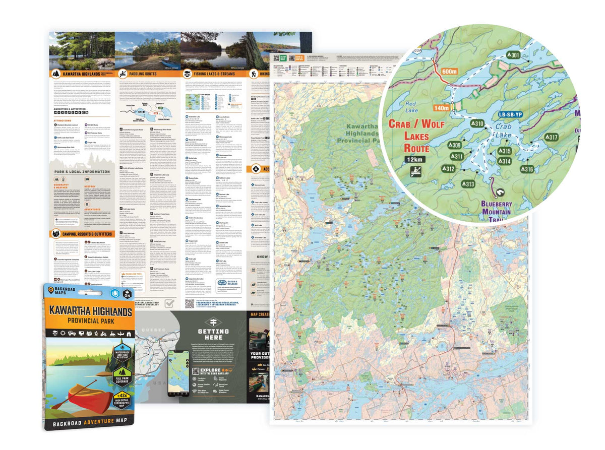
Kawartha Highlands Provincial Park Ontario - Park Map
1:42,000 Scale
Large Format
5x8.25 inches (folded) / 27.8×39.4 inches (unfolded)
Waterproof & Tear-Resistant
Covering all of Kawartha Highlands Provincial Park, this Ontario topographic recreation map highlights all the paddling routes, backcountry campsites, paddling access points, and portages for canoers, campers, anglers, hikers, and backcountry enthusiasts. Showcasing frontcountry and wilderness campsites, portage locations and distances, boat launches, fishing hotspots, and waterfalls, there is a lifetime of outdoor adventures to be found here.
This map features our industry-leading topographic contours and relief shading, as well as roads, padding routes and trails, and ATV and snowmobile areas outside the park. Included on the map are Apsley, Buckhorn, Burleigh Falls, Catchacoma, Anstruther Lake, Buzzard Lake, Chandos Lake, Gold Lake, Mississagua River, Rathbun Lake, Serpentine Lake, Shark Lake, Sucker Lake, Turtle Lake, and more! No other map covers all of Kawartha Highlands Provincial Park with this level of recreation detail.
The printed version of the map is displayed at 1:42,000 scale on 5x8.25 inches (folded) / 27.8×39.4 inches (unfolded) paper on a durable waterproof synthetic material.
Crown land covers about 94% of British Columbia, and most of it is open for free camping. Here is how the rules work, the best regions to head to, how...

Many anglers overlook Saskatchewan, assuming it’s nothing but prairie, but they’re missing out on some truly exceptional fishing. The province is home to more than 100,000 lakes, a fact that...

From remote wilderness and scenic waterways to unique geological formations and abundant wildlife, Saskatchewan is full of “hidden gems” waiting to be discovered.

Summary: This guide covers everything BC spring bear hunters need for 2026: when seasons open across key WMUs, which regions; Cariboo, Thompson, Fraser Valley, hold the best opportunity, how to...

Did you know 89% of Canada is crown land, and most of it is free to camp on? No reservations, no fees, no crowded campgrounds. But knowing where you're allowed...

From Cape Scott to Strathcona and the Broughton Archipelago, discover the best Northern Vancouver Island provincial parks for backcountry hiking, camping and sea kayaking.

Looking for the best Northern Vancouver Island camping? This guide covers top BC Recreation Sites and Forest Service campsites near Port McNeill, Gold River, Port Hardy and Campbell River, including...

This in-depth guide compares the Top 3 Best Hunting Maps for Canada in 2026: Backroad Maps, onX Hunt, and iHunter. It covers Alberta hunting zones maps, Ontario hunting area maps,...

Scale
Area
Dimensions
Pages
Release
Features