Loading...
SOON63 Wall Map - Tobermory
Southern Ontario
$4995
Unit price
/
Unavailable
Couldn't load pickup availability
Scale & Dimensions
Scale & Dimensions
Map Scale: Created at
Note: In case of multiple options, the actual map scale will vary depending on the wall map size you choose.
Dimensions: 61 x 94 cm (24 x 37 inches)
Area Covered
Area Covered
This map includes
Map Features
Map Features
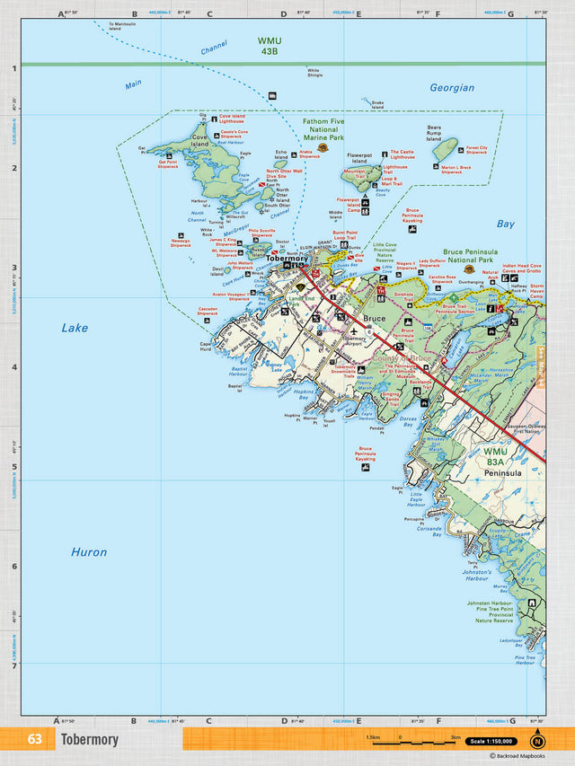
This recreation topographic map for Tobermory highlights all the logging/resource roads, hunting areas, fishing lakes & streams, campsites, paddling routes for canoeing and kayaking, wildlife viewing areas, multi-use trails for hiking, biking, horseback riding, cross-country skiing and snowshoeing, motorized trails for ATVing and snowmobiling & more. Covering 1,090 km2 (420 mi2), this 1:50,000 scale map measures 29 x 38 km (18 x 24 mi), providing you with more topographic and recreational detail for the Niagara-on-the-Lake area than any other map on the market. New features include expanded road and trail data and countless recreational Points of Interest. Included on this map are Cove Island, Fathom Five National Marine Park, Bear's Rump Island, Bruce Peninsula National Park, Bruce Peninsula, Tobermory, Cameron Lake, Flowerpot Island, Cyprus Lake and more. This map also covers the following Wildlife Management Units: WMU 43B, WMU 83A. Tobermory - Southern Ontario comes printed on waterproof synthetic material for extra durability.
The Wall Map Format
The Wall Map version of this map features a minimal layout to display nicely to fit into common picture frame sizes so you can hang it on the cabin, home or workshop wall.
All maps come printed on waterproof synthetic material for extra durability.