Loading...
NWON1 Wall Map - Lac La Croix
Northwestern Ontario
$4995
Unit price
/
Unavailable
Couldn't load pickup availability
Scale & Dimensions
Scale & Dimensions
Map Scale: Created at
Note: In case of multiple options, the actual map scale will vary depending on the wall map size you choose.
Dimensions: 61 x 94 cm/24 x 37 inches
Area Covered
Area Covered
This map includes
Map Features
Map Features
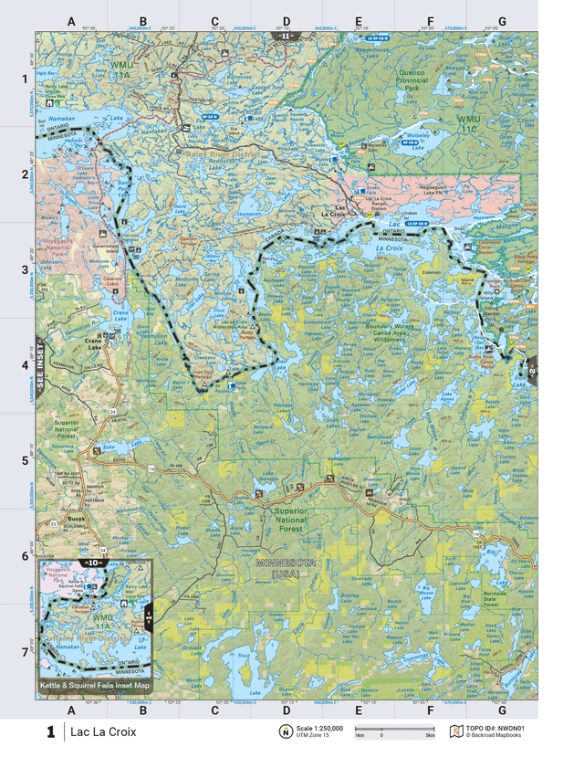
This recreation topographic map for Lac La Croix highlights all the logging/resource roads, hunting areas, fishing lakes & streams, campsites, paddling routes for canoeing and kayaking, wildlife viewing areas, multi-use trails for hiking, biking, horseback riding, cross-country skiing and snowshoeing, motorized trails for ATVing and snowmobiling & more. Covering 3,040 km2 (1,175 mi2), this 1:85,000 scale map measures 48 x 63.5 km (30 x 39.5 mi), providing you with more topographic and recreational detail than any other map on the market. New features include expanded road and trail data and countless recreational Points of Interest. Included on this map are Lac la Croix, Quetico Provincial Park, Thompson Lake and Wolseley Lake, plus parts of Minnesota including the Superior National Forest and Voyageurs National Park. This map also covers Wildlife Management Units: WMU 11A, WMU 11C.Lac La Croix - Northwestern Ontario comes printed on waterproof synthetic material for extra durability.The printed version is printed on a durable waterproof synthetic material on 61 x 94 cm (24 x 37 inch) sheets. It comes folded with the option to have the map come unfolded as a Wall Map in two different sizes. The Wall Maps have been customized to display nicely and fit into common picture frame sizes so you can hang on the cabin, home or workshop wall.Ê
The Wall Map Format
The Wall Map version of this map features a minimal layout to display nicely to fit into common picture frame sizes so you can hang it on the cabin, home or workshop wall.
All maps come printed on waterproof synthetic material for extra durability.