NOBC112 Wall Map - Thinahtea Lake
Northern BC
Couldn't load pickup availability
Scale & Dimensions
Scale & Dimensions
Map Scale: Created at
Note: In case of multiple options, the actual map scale will vary depending on the wall map size you choose.
Dimensions: 61 x 94 cm/24 x 37 inches
Area Covered
Area Covered
This map includes
Map Features
Map Features
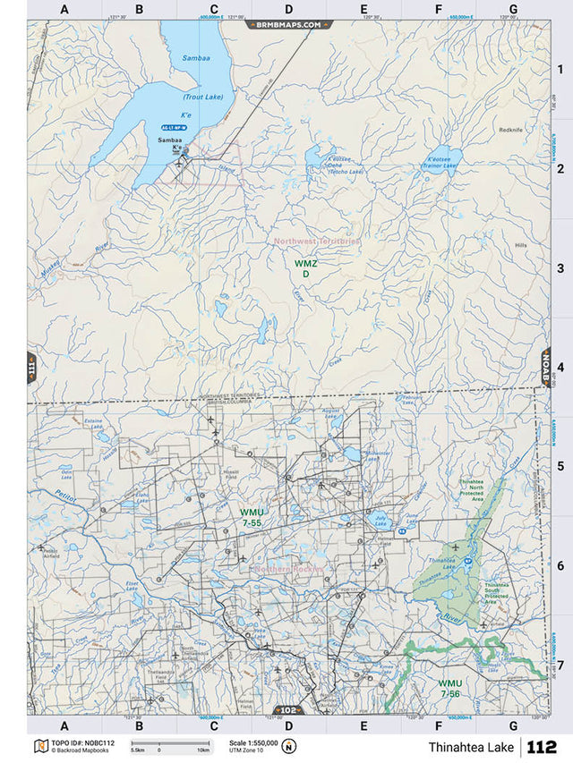
This recreation map for the Thinahtea Lake area highlights all the logging and resource roads, recreational features and trails for hiking, mountain biking, ATVing, snowmobiling, skiing, snowshoeing, fishing, camping, hunting, canoeing, kayaking, wildlife viewing and more. New features include private land and labelled fish species, plus new roads, recreational trails and Points of Interest. No other map for the area provides you with this level of recreational or topographic detail. Measuring 105 x 140 km (65 x 87 mi), this 1:185,000 scale map covers 14,750 km2 (5,695 mi2) in total and includes Thinahtea Lake, Thinahtea South Protected Area, Petitot River, July Lake, June Lake, Thinahtea North Protected Area, Thinahtea Creek, North Helmet Airfield and more! This map also covers the following Wildlife Management Units: WMU 7-55 Peace, WMU 7-56 Peace. Thinahtea Lake - Northern BC comes printed on waterproof synthetic material for extra durability.
The Wall Map Format
The Wall Map version of this map features a minimal layout to display nicely to fit into common picture frame sizes so you can hang it on the cabin, home or workshop wall.
All maps come printed on waterproof synthetic material for extra durability.