CCBC20 Wall Map - Bella Bella
Cariboo Chilcotin Coast BC
Couldn't load pickup availability
Scale & Dimensions
Scale & Dimensions
Map Scale: Created at
Note: In case of multiple options, the actual map scale will vary depending on the wall map size you choose.
Dimensions: 61 x 94 cm/24 x 37 inches
Area Covered
Area Covered
This map includes
Map Features
Map Features
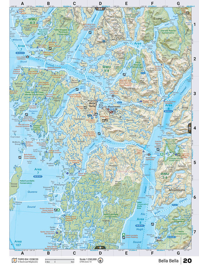
This recreation topographic map for the Bella Bella area highlights all the logging roads, trails and recreational Points of Interest including hunting, camping, hiking, mountain biking, canoeing, kayaking, backcountry skiing, wildlife viewing, ATVing, snowmobiling and more. No other map provides you with this level of recreational and topographic detail for the Homathko River area. Covering the Outer Central Coast Islands Conservancy, Hakai/Luxvbalis Conservancy, Lady Douglas-Don Penninsula Conservancy,Spiller Channel, Seaforth Channe, Fisher Channel, Old Bella Bella, Campbell Island, Shearwater, Namu, Bella Bella and more, this map contains new features such as private land and labelled fish species. The 1:85,000 scale map covers 3,040 km2 (1,175 mi2), measuring 50 x 63.5 km (30 x 39.5 mi). This map also covers the following Wildlife Management Units: WMU 5-8 Cariboo, WMU 5-9 Cariboo, WMU 6-3 Skeena. Bella Bella - Cariboo Chilcotin Coast BC comes printed on waterproof synthetic material for extra durability.
The Wall Map Format
The Wall Map version of this map features a minimal layout to display nicely to fit into common picture frame sizes so you can hang it on the cabin, home or workshop wall.
All maps come printed on waterproof synthetic material for extra durability.