Loading...
VCBC53 Wall Map - Lillooet
Vancouver, Coast & Mountains BC
$4995
Unit price
/
Unavailable
Couldn't load pickup availability
Scale & Dimensions
Scale & Dimensions
Map Scale: Created at
Note: In case of multiple options, the actual map scale will vary depending on the wall map size you choose.
Dimensions: 61 x 94 cm/24 x 37 inches
Area Covered
Area Covered
This map includes
Map Features
Map Features
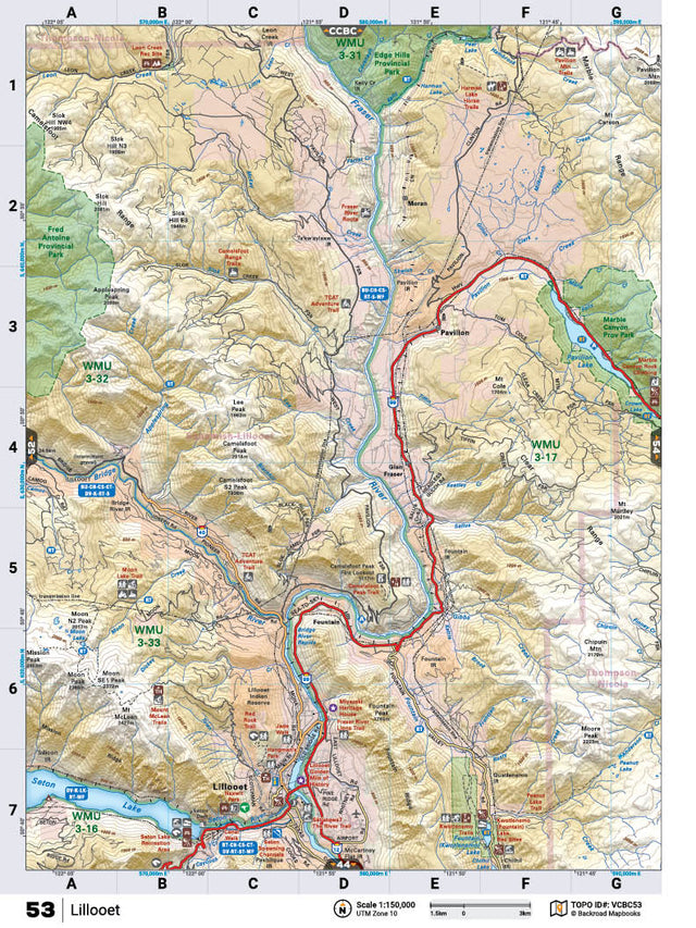
This recreation topographic map for the Lillooet area highlights all the logging roads, trails and recreational Points of Interest including hunting, camping, hiking, mountain biking, canoeing, kayaking, backcountry skiing, wildlife viewing, ATVing, snowmobiling and more. No other map for the area provides you with this level of recreational or topographic detail. Covering 1,090 km2 (420 mi2), this 1:32,000 scale map measures 29 x 38 km (18 x 24 mi) and covers Lillooet, Seton Lake, Fraser River, Bridge River, Marble Canyon Provincial Park, Edge Hills Provincial Park, Fred Antoine Provincial Park and more! This map also covers the following Wildlife Management Units: WMU 3-16 Thompson, WMU 3-17 Thompson, WMU 3-31 Thompson, WMU 3-32 Thompson, WMU 3-33 Thompson. Lillooet - Vancouver Coast & Mountains BC comes printed on waterproof synthetic material for extra durability.
The Wall Map Format
The Wall Map version of this map features a minimal layout to display nicely to fit into common picture frame sizes so you can hang it on the cabin, home or workshop wall.
All maps come printed on waterproof synthetic material for extra durability.