TOBC04 Wall Map - Osoyoos
Thompson Okanagan BC
Couldn't load pickup availability
Scale & Dimensions
Scale & Dimensions
Map Scale: Created at
Note: In case of multiple options, the actual map scale will vary depending on the wall map size you choose.
Dimensions: 61 x 94 cm/24 x 37 inches
Area Covered
Area Covered
This map includes
Map Features
Map Features
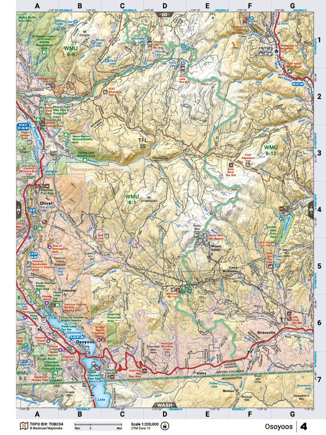
This recreation topographic map for the Osoyoos area highlights all the logging roads, trails and recreational Points of Interest including hunting, camping, hiking, mountain biking, canoeing, kayaking, backcountry skiing, snowshoeing, cross-country skiing, wildlife viewing, ATVing, snowmobiling and more. No other map for the area provides you with this level of recreational or topographic detail. Special features include private land and countless roads, trails and recreational Points of Interest. Covering 1,950 km2 (750 mi2) in total, this 1:65:000 scale map measures 38 x 51 km (23.5 x 32 mi) and includes Osoyoos, Okanagan River, Osoyoos Lake, Conkle Lake, Conkle Lake Provincial Park, Mount Baldy and more! This map also covers the following Wildlife Management Units: WMU 8-12 Okanagan, WMU 8-1 Okanagan, WMU 8-2 Okanagan, WMU 8-9 Okanagan. Osoyoos - Thompson Okanagan BC comes printed on waterproof synthetic material for extra durability.
The Wall Map Format
The Wall Map version of this map features a minimal layout to display nicely to fit into common picture frame sizes so you can hang it on the cabin, home or workshop wall.
All maps come printed on waterproof synthetic material for extra durability.