Loading...
CRCR13 Wall Map - Wapta Icefield
Canadian Rockies
$4995
Unit price
/
Unavailable
Couldn't load pickup availability
Scale & Dimensions
Scale & Dimensions
Map Scale: Created at
Note: In case of multiple options, the actual map scale will vary depending on the wall map size you choose.
Dimensions: 61 x 94 cm/24 x 37 inches
Area Covered
Area Covered
This map includes
Map Features
Map Features
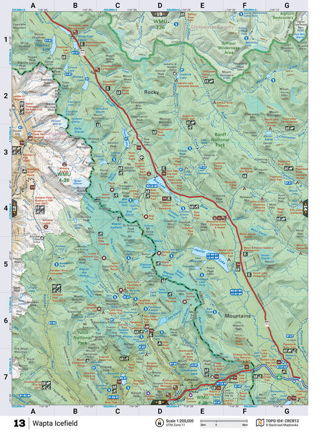
This recreation topographic map for Wapta Icefield highlights all the roads, fishing lakes & streams, front and backcountry campsites, paddling routes for canoeing and kayaking, wildlife viewing areas, multi-use trails for hiking, backcountry skiing, snowshoeing, mountain biking, horseback riding & more. Covering 1,950 km2 (753 mi2), this map measures 38 x 51 km (24 x 32 mi), providing you with more topographic and recreational detail for the Whiteswan Lake area than any other map on the market. Special features include private land and countless roads, trails and recreational Points of Interest. Included on this map are Wapta Icefield, Siffleur Wilderness Area, Banff National Park, Hector Lake, Siffleur River, Mistaya River, Bow Lake, Kicking Horse River and more! Wapta Icefield - Canadian Rockies comes printed on waterproof synthetic material for extra durability.
The Wall Map Format
The Wall Map version of this map features a minimal layout to display nicely to fit into common picture frame sizes so you can hang it on the cabin, home or workshop wall.
All maps come printed on waterproof synthetic material for extra durability.