Tweedsmuir Park - Alexander Mackenzie Heritage Trail BC - Park Map
Cariboo Chilcotin Coast BC 💧 Waterproof Map
Couldn't load pickup availability
Specs
Specs
Map Scale: 1:150,000 Scale
Release: 2025
Dimensions: 5x8.25 inches (folded) / 27.8×39.4 inches (unfolded)
Double-Sided
Area Covered
Area Covered
Map Features
Map Features

Tweedsmuir Park - Alexander Mackenzie Heritage Trail BC - Park Map
1:150,000 Scale
Large Format
5x8.25 inches (folded) / 27.8×39.4 inches (unfolded)
Waterproof & Tear-Resistant
Description
Description
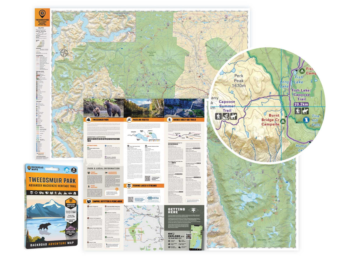
Highlighting the Tweedsmuir Park, the Alexander Mackenzie Heritage Trail, the Turner Lake Canoe Route, and the Bella Coola Valley, this waterproof map features the entire canoe route and its access points, campsites, cabins, portage trails with distance markers, fish species, hiking trails and waterfalls. Use this Adventure map for fishing, camping, exploring, canoeing, kayaking, wildlife viewing and more.
With 1:10,000 water and road data, no other map for the area provides you with this level of recreational or topographic detail. This map includes Tweedsmuir Park, Alexander Mackenzie Heritage Trail, Turner Lake Canoe Route, Bella Coola Valley, Anahim Lake, Hunlen Falls, Burnt Bridge Loop Trail, Crystal Lake Trail, Octopus Lake Trail, Ptarmigan Lake Area Trails, Rainbow Range Trail, and more!
The printed version of the map is displayed at 1:150,000 scale on 5x8.25 inches (folded) / 27.8×39.4 inches (unfolded) paper on a durable waterproof synthetic material.
Print Features:
-
NEW BIGGER FORMAT: 5x8.25 inches (folded) / 27.8×39.4 inches (unfolded)
- NEW ADVENTURES: In addition to the maps, we have included several trip planning sections with information about the park, camping, outfitters, picnic areas, paddling routes, fishing lakes & streams, hiking & multi-use trails, and tips & techniques.
- Printed on durable waterproof, and tear-resistant material
- Includes industry-leading cartographic detail and state-of-the-art relief shading
- Countless points of interest, hiking trails, campsites, boat launches, paddling routes and more!
In Partnership With Hälle Flygare