Strathcona Provincial Park BC - Park Map
Vancouver Island BC 💧 Waterproof Map
Couldn't load pickup availability
Specs
Specs
Map Scale: 1:110,000 Scale
Release: 2025
Dimensions: 5x8.25 inches (folded) / 27.8×39.4 inches (unfolded)
Double-Sided
Area Covered
Area Covered
Map Features
Map Features

Strathcona Provincial Park BC - Park Map
1:110,000 Scale
Large Format
5x8.25 inches (folded) / 27.8×39.4 inches (unfolded)
Waterproof & Tear-Resistant
Description
Description
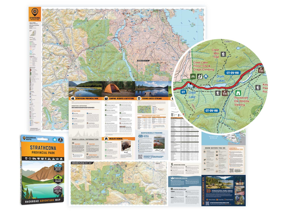
Covering all of Strathcona Provincial Park on Vancouver Island, this British Columbia topographic recreation map highlights all the access roads and trails for hikers, bikers, skiers and backcountry enthusiasts. Showcasing frontcountry and wilderness campsites, huts and cabins, picnic sites, recreation sites, viewpoints, waterfalls, climbing areas and fishing lakes and rivers, there is a lifetime of outdoor adventures to be found here.
This map features our industry-leading topographic contours and relief shading, as well as roads, recreation sites and trails and ATV and snowmobile areas outside the park. Included on the map are Campbell River, Courtenay, Gold River, Bedwell River, Buttle Lake, Comox Glacier, Della Falls, Forbidden Plateau, Mount Washington Ski Area, Myra Falls, Oyster River, Upper Campbell Lake and more! No other map covers all of Strathcona Provincial Park with this level of recreation detail.
The printed version of the map is displayed at 1:110,000 scale on 5x8.25 inches (folded) / 27.8×39.4 inches (unfolded) paper on a durable waterproof synthetic material.
Print Features:
-
NEW: Now in an easy-to-read, bigger format, 5x8.25 inches (folded) / 27.8×39.4 inches (unfolded)
- NEW: Features a high-detail map of the adventure-rich Forbidden Plateau
- NEW: In addition to the maps, we have included several trip planning sections with information about the park, camping, resorts, outfitters, paddling routes, fishing lakes & streams, hiking & multi-use trails, wildlife viewing and tips & techniques.
- Printed on durable waterproof, and tear-resistant material
- Includes industry-leading cartographic detail and state-of-the-art relief shading
- Countless points of interest, hiking trails, campsites, boat launches, paddling routes and more!
In Partnership With Strathcona Park Lodge