Kananaskis Lakes - Peter Lougheed Provincial Park AB - Wall Map
Canadian Rockies
Couldn't load pickup availability
Scale & Dimensions
Scale & Dimensions
Map Scale: Created at
Note: In case of multiple options, the actual map scale will vary depending on the wall map size you choose.
Dimensions: 3 Options Available
Area Covered
Area Covered
This map includes
Map Features
Map Features
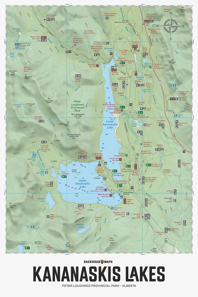
Focusing on the Kananaskis Lakes area of Peter Lougheed Provincial Park Alberta, this Adventure topographic map highlights all the highways and secondary roads, trails for hiking, cross-country skiing, mountain biking, snowshoeing and horseback riding, fishing lakes and rivers, picnic areas, campgrounds, viewpoints, waterfalls, fire lookouts and more! This Adventure map features our industry-leading topographic contours and relief shading along with lake bathymetry (depth contours) for the Upper and Lower Kananaskis Lakes. Also included on the map are Aster Lake, Canyon Campground, Elk Pass, Elpoca Falls, Great Divide Trail, Hidden Lake, Interlakes Campground, King Creek Picnic Area, Lower Lake Campground, Mount Warspite, Pocaterra Trail, Rawson Lake, Smith Dorrien Creek and more!
The Wall Map Format
The Wall Map version of this map features a minimal layout to display nicely to fit into common picture frame sizes so you can hang it on the cabin, home or workshop wall.
All maps come printed on waterproof synthetic material for extra durability.