Kakwa Provincial Parks - Alberta & BC Wall Map
Canadian Rockies
Couldn't load pickup availability
Scale & Dimensions
Scale & Dimensions
Map Scale: Created at
Note: In case of multiple options, the actual map scale will vary depending on the wall map size you choose.
Dimensions: 3 Options Available
Area Covered
Area Covered
This map includes
Map Features
Map Features
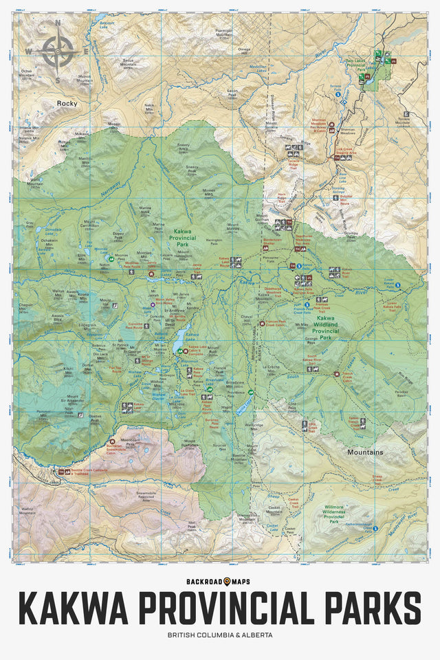
Covering Kakwa Wildland Provincial Park in Alberta and Kakwa Provincial Park and Protected Area in BC, this topographic recreation map shows you all the access roads, trails for hiking, mountain biking, horseback riding, snowshoeing, cross-country skiing, ATVing and snowmobiling, backcountry huts and cabins, fishing lakes and rivers, waterfalls, viewpoints, recreation sites, campgrounds, backcountry campsites and more! Using 1:10,000 & 1:20,000 scale data, this map features our industry-leading topographic contours and relief shading, giving you more detail than any other map for this area. Included on the map are Kakwa Falls, Kakwa Lake, Broadview Lake, Cecilia Lake, Corniche Pass, Deadhorse Meadows, Francis Peak, Jarvis Lakes, McGregor River, Moonias Pass, Mount Ian Monroe, Mount Ruth, Narraway River, Sulfur Ridge, Torrens River, Trench Creek, Two Lakes, Walker Creek Forest Service Road and more!
The Wall Map Format
The Wall Map version of this map features a minimal layout to display nicely to fit into common picture frame sizes so you can hang it on the cabin, home or workshop wall.
All maps come printed on waterproof synthetic material for extra durability.