Banff & Area - Banff National Park AB - Wall Map
Canadian Rockies
Couldn't load pickup availability
Scale & Dimensions
Scale & Dimensions
Map Scale: Created at
Note: In case of multiple options, the actual map scale will vary depending on the wall map size you choose.
Dimensions: 3 Options Available
Area Covered
Area Covered
This map includes
Map Features
Map Features
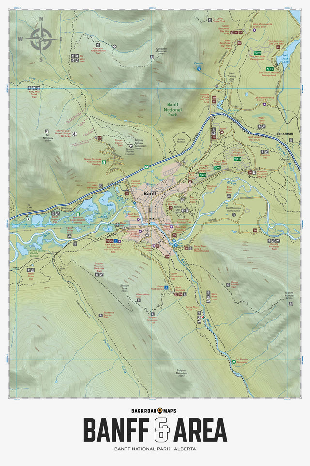
Focusing on the Banff town site within Banff National Park, this BRMB Adventure topographic map highlights all the trails for hiking, mountain biking, cross-country skiing, horseback riding and snowshoeing, paddling routes for canoeing and kayaking, fishing lakes and rivers, campgrounds, historic sites, city roads and highways, downhill ski areas, viewpoints, hot springs and more! No other map provides as much recreational information and topographic detail around the Banff city area as this one. Using 1:20,000 scale data, this map features our industry-leading topographic contours and relief shading and includes the Banff city, Banff Gondola, Bow River, Cave and Basin Hot Springs, Forty Mile Creek, Mount Norquay Ski Area, Stoney Squaw Mountain, Sulphur Mountain Trail, Sundance Canyon Trail, Tunnel Mountain Campgrounds, Vermillion Lakes and more!
The Wall Map Format
The Wall Map version of this map features a minimal layout to display nicely to fit into common picture frame sizes so you can hang it on the cabin, home or workshop wall.
All maps come printed on waterproof synthetic material for extra durability.