Height of the Rockies Provincial Park BC - Wall Map
Canadian Rockies
Couldn't load pickup availability
Scale & Dimensions
Scale & Dimensions
Map Scale: Created at
Note: In case of multiple options, the actual map scale will vary depending on the wall map size you choose.
Dimensions: 3 Options Available
Area Covered
Area Covered
This map includes
Map Features
Map Features
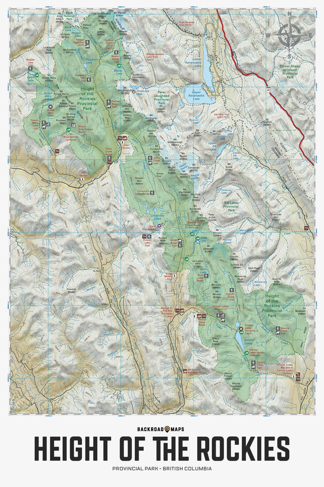
Covering Height of the Rockies Provincial Park in BC, this topographic recreation map highlights all the campgrounds, forest service access roads, trails for hiking, horseback riding, mountain biking, cross-country skiing and snowshoeing, backcountry huts and cabins, fishing rivers and lakes, surrounding areas and more! Shown at 1:75,000 scale, this map features our industry-leading topographic contours and relief shading. Included on the map are Connor Lakes, Elk Lakes, Forsyth Creek, Great Divide Trail, Joffre Creek Trail, Kananaskis Lakes, Limestone Lakes, Maiyuk Creek, Mount King George, Palliser River, Queen Mary Lake, Ralph Lake, The Royal Group Mountains, White River and more!
The Wall Map Format
The Wall Map version of this map features a minimal layout to display nicely to fit into common picture frame sizes so you can hang it on the cabin, home or workshop wall.
All maps come printed on waterproof synthetic material for extra durability.