Loading...
PEI7 Wall Map - Summerside
Prince Edward Island
$4995
Unit price
/
Unavailable
Couldn't load pickup availability
Scale & Dimensions
Scale & Dimensions
Map Scale: Created at
Note: In case of multiple options, the actual map scale will vary depending on the wall map size you choose.
Dimensions: 61 x 94 cm/24 x 37 inches
Area Covered
Area Covered
This map includes
Map Features
Map Features
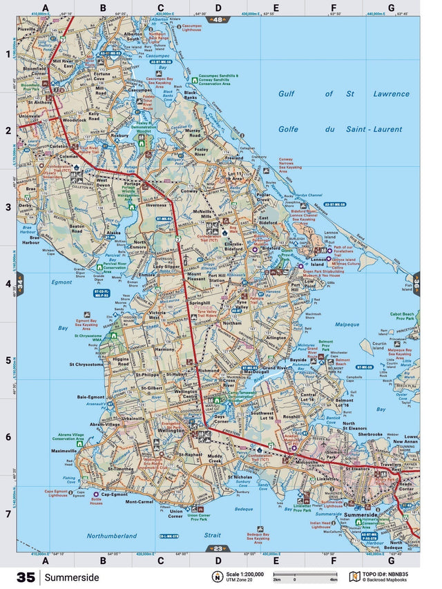
This recreation topographic map for Summerside highlights all the logging/resource roads, hunting areas, fishing lakes & streams, campsites, paddling routes for canoeing and kayaking, wildlife viewing areas, multi-use trails for hiking, biking, horseback riding, cross-country skiing and snowshoeing, motorized trails for ATVing and snowmobiling & more. Covering 1,925 km2 (745 mi2), this 1:65,000 scale map measures 38 x 50 km (24 x 31 mi), providing you with more topographic and recreational detail for the Yarmouth area than any other map on the market. Special features include the addition of Crown land areas and countless new roads, trails and recreational Points of Interest. Included on this map are Summerside, Northumberland Strait, Linkletter Provincial Park, Belmont Provincial Park, Cabot Beach Provincial Park, Malpeque Bay and more! Summerside - PEI comes printed on waterproof synthetic material for extra durability.
The Wall Map Format
The Wall Map version of this map features a minimal layout to display nicely to fit into common picture frame sizes so you can hang it on the cabin, home or workshop wall.
All maps come printed on waterproof synthetic material for extra durability.