Mount Revelstoke National Park BC - Wall Map
Kootenay Rockies BC
Couldn't load pickup availability
Scale & Dimensions
Scale & Dimensions
Map Scale: Created at
Note: In case of multiple options, the actual map scale will vary depending on the wall map size you choose.
Dimensions: 3 Options Available
Area Covered
Area Covered
This map includes
Map Features
Map Features

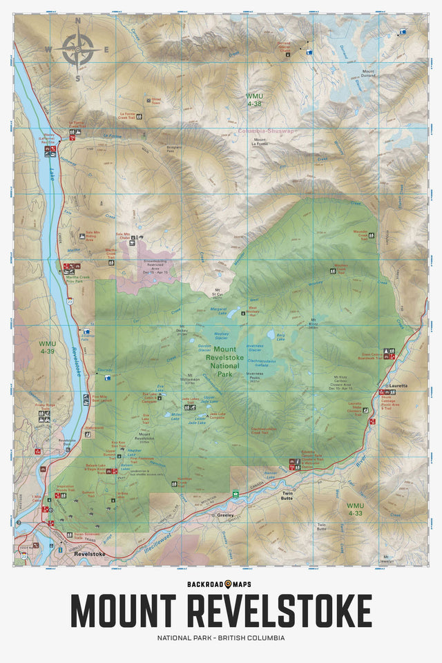
Covering Mount Revelstoke National Park and the surrounding area, this British Columbia topographic recreation map highlights all the access roads, backcountry huts and cabins, campgrounds, trails for hiking, horseback riding, mountain biking, cross-country skiing and snowshoeing, fishing rivers and lakes, rock climbing areas, viewpoints, waterfalls and more! This Adventure map features our industry-leading topographic contours and relief shading and includes the areas of Eva Lake, First Footsteps Trail, Giant Cedars Boardwalk Trail, Illecillewaet River, Inverness Glacier, Jade Lake, Lake Revelstoke, Margaret Lake, Meadows in the Sky Parkway, Mount Revelstoke, Revelstoke, Silvertip Canyon Falls, Woolsey Creek and more!
The Wall Map Format
The Wall Map version of this map features a minimal layout to display nicely to fit into common picture frame sizes so you can hang it on the cabin, home or workshop wall.
All maps come printed on waterproof synthetic material for extra durability.