Unlock the Outdoors with 25% Off! Ends December 2nd, 2024

6th Edition

Vancouver, Coast & Mountains BC Backroad Mapbook

$2545 $2995

Barcode: 6-22098-00265-2

Durable Spiral-Bound Format

ISBN: 978-1-989175-19-4
Release: 2022
Dimensions: 21.5cm x 28cm (8.5" x 11")

Map Scale & Area

Map Scale: 54 maps @ 1:150,000

This mapbook includes Abbotsford, Cache Creek, Chilliwack, Gibsons, Gold Bridge, Greater Vancouver, Harrison Hot Springs, Hope, Lillooet, Pemberton, Powell River, Sechelt, Squamish, Sunshine Coast, Whistler, & more

Features Included

Highways, Logging Roads, Land & Water Features, Parks, Adventure Points of Interest, Campgrounds, Hiking Trails, Motorized Trails, Paddling Routes, Hunting & Fishing Areas, Winter Recreation and more

Description

Covering the southwestern portion of British Columbia, including the Greater Vancouver area and the cities of Squamish, Whistler, Lillooet, Hope and Chilliwack, this Mapbook is your ultimate guide to camping, hiking, fishing, ATVing, hunting, snowmobiling, paddling and wildlife viewing in this incredible part of the province. From the laid-back communities of the Sunshine Coast to the lush rainforest of EC Manning Provincial Park, the alpine peaks and glacier-fed lakes of Garibaldi Provincial Park, the winding logging roads around Harrison Lake and beyond, the Vancouver, Coast & Mountains region is full of outdoor adventure opportunities.

The 6th Edition Vancouver Coast & Mountains Backroad Mapbook features several additions and expansions from our last edition. You will find an updated and expanded Community Profiles section, several additions to the Adventure listings, updated fish stocking and hiking trail charts, new multi-day overland driving routes for off-road enthusiasts and a new Rock Climbing Adventure section. Our maps now feature private and leased land, labelled sportfish species for lakes and rivers, plus countless new recreation POI's, roads, trails and paddling routes.

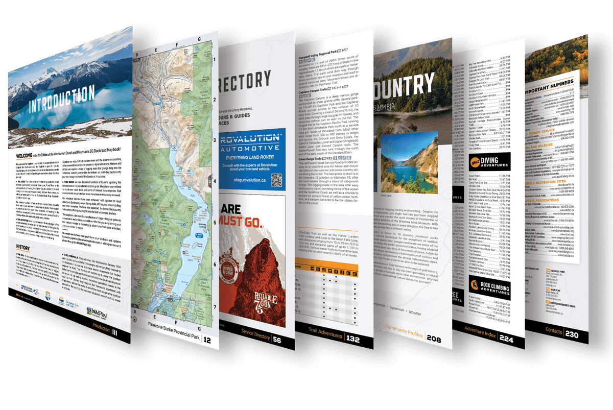
The printed version of the mapbook comes in the convenient 21.5 x 28 cm (8.5 x 11 inch) mapbook format with a heavy-duty spiral-bound cover. The 232 page book includes 54 maps at 1:150,000 scale, along with a dozen Outdoor Adventure sections, a Service Provider Directory, Map and Adventure Index, Trip Planning tools and more. With over 55,000 kilometres of roads to view including the most complete logging and industrial road coverage available, these books are ideal for navigating on road trips and planning from home.

Print Features

  • Map Key & Legend
  • Topographic Maps
    • 54 @ 1:150,000 Scale Maps
  • All-Inclusive Adventure Section
    • Backroad Attractions
    • Fishing Locations
    • Hunting Areas
    • Paddling Routes
    • Parks & Campsites
    • Trail Systems
    • ATV Routes
    • Snowmobile Areas
    • Wildlife Viewing
    • Winter Recreation
    • Backcountry Huts & Cabins
  • Community Profiles
    • 3 Regions & 14 Communities
  • Service Directory
    • Accomodations
    • Sales & Services
    • Tours & Guides
  • Index
    • Adventure Index
    • Map Index
  • Trip Planning Tools

Adventures Included


Backroad Adventures

In the latest edition of our Vancouver, Coast & Mountains Backroad Mapbook you will find over 85 backroad attractions spread throughout the region, accessible via the 55,000 kilometres (34,175 miles) of roads we show on our maps. This includes museums, hot springs, big trees, viewpoints, ghost towns, mine sites and much more, such as the Lynn Canyon Suspension Bridge, Othello Tunnels, Sloquet Hot Springs, and the impressive Shannon Falls near Squamish.

Fishing Adventures

Ranging from fast-flowing mountain streams to big, lazy rivers, lakes both big and small and some of the best ocean fishing in the world, the 6th Edition Vancouver, Coast & Mountains Backroad Mapbook contains over 300 comprehensive listings for the best fishing spots in the region. Fish species are clearly labelled on the maps and you will find written descriptions complete with information on stocking, regulations, access, techniques and more. We also include easy-to-read stocking charts for those species that are stocked in the region's lakes and rivers. From salmon hot spots to steelhead, cutthroat and rainbow trout pools, we have you covered.

Hunting Adventures

The hunting opportunities in the Lower Mainland Region 2 are vast and varied, ranging from big mammals like black-tailed deer and black bear to gamebirds and waterfowl, plus elusive prey such as bighorn sheep in the remote higher elevation areas. In the latest edition of the Vancouver, Coast & Mountains Backroad Mapbook you will find thorough written descriptions for the area's 20 Wildlife Management Units, from Gold Bridge to Boston Bar, Chilliwack and beyond, complete with information on species, regulations, access and more.

Paddling Adventures

From exploring the incredible biodiversity of Desolation Sound Marine Provincial Park in a sea kayak to charging the whitewater of the Birkenhead River or a flatwater trip along the Powell Forest Canoe Route, there is something for every type of paddler in the Vancouver, Coast & Mountains region. In the latest edition of our Backroad Mapbook for the area you will find over 120 intricate lake, river and ocean paddling routes complete with information on distance, difficulty, portages, put-ins/take-outs, highlights and more.

Park Adventures

Many of the most spectacular natural areas of the Vancouver, Coast & Mountains region are protected by a well-developed system of national and provincial parks, including the popular, easy-access Golden Ears Provincial Park, the remote and rugged Stein Valley Provincial Park, the high-elevation Garibaldi Provincial Park and the quiet confines of E.C. Manning Provincial Park. In the latest edition of our Vancouver, Coast & Mountains Backroad Mapbook you will find comprehensive listings for over 160 of the region's parks complete with information on access, activities, amenities, highlights and more.

Rec Site Adventures

The Vancouver, Coast & Mountain area is full of recreation sites that offer incredible opportunities for camping, picnicking, fishing, hiking and nature appreciation, ranging from developed, easy-access sites to rustic clearings deep in the backcountry. In the latest edition Vancouver, Coast & Mountains Backroad Mapbook you will find over 115 listings for recreation sites resting next to lakes and the extensive backcountry of the region complete with information on size, access, amenities, activities, and more.

Trail Adventures

From trail running through the coastal rainforest to scaling ancient volcanic rock formations such as the Black Tusk, to casual walks through urban parks and exciting mountain bike rides on community-built trails, there are endless opportunities for trail exploring in the Vancouver, Coast & Mountains region. In the latest edition of our Vancouver, Coast & Mountains Backroad Mapbook you will find over 410 intricate listings for multi-use trails throughout the region complete with information on trailhead access, trail length, elevation gain, highlights and more. Also included here are handy trail charts for the region's main hiking areas including Buntzen Lake, Vancouver's North Shore, EC Manning Park, Garibaldi Park and Golden Ears Provincial Park and the Trans Canada Trail.

ATV Adventures

From muddy forest tracks to wide-open play areas and winding mountain routes that lead to stunning viewpoints and hidden waterfalls, ATVers have a lot of options for riding in the Vancouver, Coast & Mountains region. In the latest edition of our Southwestern BC Backroad Mapbook you will find close to 40 elaborate listings for ATV riding areas such as those in the Chilliwack River Valley, the Coalmont/Tulameen Area, Gold Bridge and more, complete with information on staging areas, trail length, difficulty, elevation gain and much more. New to this edition are descriptions of multi-day overland routes which explore deep into the backcountry of this region.

Snowmobile Adventures

The snowmobiling terrain in the Vancouver, Coast & Mountains region is some of the best in the country, with the areas around Squamish, Pemberton and Lillooet offering deep snow, big open bowls and tons of trails and logging roads to explore. In the 6th Edition Vancouver, Coast & Mountains Backroad Mapbook you will find close to 35 comprehensive listings for the area's best snowmobiling destinations, covering BCSFC club areas and beyond, complete with information on staging, trail distance, elevation gain, highlights and more.

Wildlife Adventures

The Vancouver, Coast & Mountains area is full of fascinating wildlife, from the whales, dolphins and sea lions of the Pacific Ocean to the black bears that roam the inland forests and the hundreds of species of birds that live and migrate through the area. In the latest edition of this Southwestern BC Backroad Mapbook you will find over 80 explicit listings for the best places to view wildlife in the area complete with information on species, access, best viewing times and more.

Winter Adventures

The Coastal Mountains area offers some of the best winter recreation in the country. From the world-famous slopes of Whistler to the incredible backcountry skiing and snowboarding terrain of Garibaldi Provincial Park and the Tetrahedron Plateau, to the many cross-country skiing, snowshoeing and fat biking trails found throughout the region, there are lots of adventures to be had in the wintertime. In your 6th Edition Vancouver, Coast & Mountains Backroad Mapbook you will find over 60 comprehensive listings for the best places to get outside in the winter complete with information on trail length, access, contact information and more.

Backcountry Hut & Cabin Adventures

The Vancouver, Coast & Mountains region is blessed with a well-established network of backcountry huts and cabins that offer shelter for hikers, skiers, snowmobilers, ATVers, hunters and others. In this bonus section in the 6th Edition Vancouver, Coast & Mountains Backroad Mapbook you will find close to 60 all-inclusive listings for backcountry huts and cabins in the area, including the huts along the Sunshine Coast Trail, the Wendy Thompson Hut in the Marriott Basin and the Harrison Hut near the Pemberton Icefield, complete with contact information, size, amenities, access and more.

Rock Climbing Adventures (New)

This new mapbook Adventure section covers the more popular rock climbing areas in the Vancouver, Coast & Mountains region. From top-roping routes with easy access to more complicated trad climbs that require additional gear and skill, there are plenty of crags to sample. We feature the best climbing areas around the Fraser Valley, North Vancouver, Squamish, Whistler/Pemberton and Powell River.

Mapbook Sections


Topographic Maps

The 6th Edition of our Vancouver, Coast & Mountains Backroad Mapbook contains 54 maps at 1:150,000 scale. Our industry-leading road coverage shows you all the highways, rural roads, forest service roads and resource roads, plus multi-use trails for hiking, cycling, horseback riding, ATVing, snowmobiling, snowshoeing and cross-country skiing. We also show you private and leased land, First Nations reserves, provincial and national parks, paddling routes and portages, ecological reserves, glaciers, wetlands and thousands of adventure Points of Interest. These 21.5 cm x 28 cm (8.5" x 11") maps are printed on thick, durable paper protected by a heavy-duty spiral-bound cover. You won't find a longer-lasting, easier-to-use or more detailed collection of maps for the Lower Mainland of BC anywhere else.

Index

Our handy index is divided into Map and Adventure sections to make it as easy to use as possible. Here you will find page numbers and map coordinates for each activity and location, community information boxes with elevation and population, activity chart information boxes for trails and fish stocking, plus important numbers and an advertiser list for easy referencing.

Service Directory

Our convenient service directory lists the best places to find accommodations, supplies and tours and guides in the Southwestern BC region, including hunting and fishing equipment in Vancouver, Port Coquitlam, Powell River, Chilliwack, Surrey, Lillooet and more.

Community Profiles

Included in this Mapbook are Community Profiles for the region's major centres, including The Fraser Valley (Coquitlam, Langley, Abbotsford, Mission, Chilliwack, Harrison Hot Springs, Hope), Sea to Sky Country (Squamish, Pemberton, Lillooet) and the Sunshine coast (Gibsons, Sechelt, Pender Harbour & Egmont, Powell River). These profiles fill you in on the best things to see and do in the outdoors around these communities, plus offer insight into local history, culture and where to find services and accommodations.

The Backroad Mapbook Format

With over 30 years of extensively researched data, our mapbooks are the most comprehensive and accurate backcountry resource on the market to date.

Vancouver, Coast & Mountains BC - Backroad Mapbook

Vancouver, Coast & Mountains BC Backroad Mapbook

$2545 $2995
Covering the southwestern portion of British Columbia, including the Greater Vancouver area and the cities of Squamish, Whistler, Lillooet, Hope and Chilliwack, this Mapbook is your ultimate guide to camping, hiking, fishing, ATVing, hunting, snowmobiling, paddling and wildlife viewing in this incredible part of the province. From the laid-back communities...

Scale

Large Area (multiple maps)

Area

Abbotsford, Cache Creek, Chilliwack, Gibsons, Gold Bridge, Greater Vancouver, Harrison Hot Springs, Hope, Lillooet, Pemberton, Powell River, Sechelt, Squamish, Sunshine Coast, Whistler, & more

Dimensions

21.5cm x 28cm (8.5" x 11")

Pages

232

Release

2022

Features

Highways, Logging Roads, Land & Water Features, Parks, Adventure Points of Interest, Campgrounds, Hiking Trails, Motorized Trails, Paddling Routes, Hunting & Fishing Areas, Winter Recreation and more
View product