Willmore Wilderness Provincial Park AB - Wall Map
Canadian Rockies
Couldn't load pickup availability
Scale & Dimensions
Scale & Dimensions
Map Scale: Created at
Note: In case of multiple options, the actual map scale will vary depending on the wall map size you choose.
Dimensions: 3 Options Available
Area Covered
Area Covered
This map includes
Map Features
Map Features
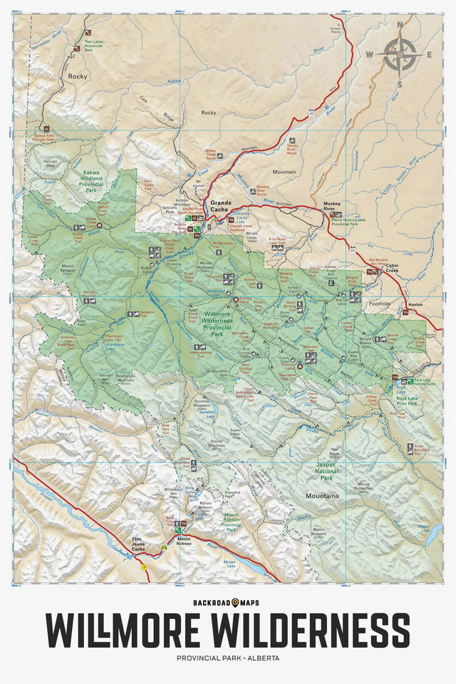
Providing a detailed overview of Willmore Wilderness Provincial Park in Alberta, this recreation map highlights all the access roads and trails, campgrounds and backcountry campsites, trailheads and notable recreation areas, larger lakes and river systems, surrounding areas and more! Using 1:50,000 scale water and road data, this map features topographic relief shading. Included on the map are A la Peche Lake, Berland River, Grande Cache, Hardscrabble Creek, Jackknife Pass, Jackpine River, Morkill Pass, Mountain Trail, Mount Mawdsey, Muddywater River, Muskeg River, Ptarmigan Lake, Rock Lake, Sheep Creek, Smoky River, Sulphur Gates, Sulphur River, Twintree Mountain and more!
The Wall Map Format
The Wall Map version of this map features a minimal layout to display nicely to fit into common picture frame sizes so you can hang it on the cabin, home or workshop wall.
All maps come printed on waterproof synthetic material for extra durability.