Atlantic Canada – VERSION 2025
Release Date: November 2024
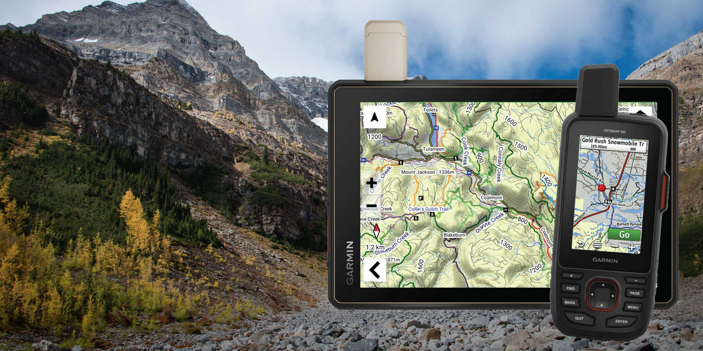
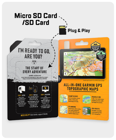
Shop GPS Maps Update your Maps
General
-
Enhanced Road
- Enhanced the ATV, Snowmobile Trail and TCT Systems
- Enhanced Paddling Routes
Newfoundland & Labrador
- Enhanced the ATV and Multi-use Trail Systems
-
New Overlander POI added
- Enhanced Water Bodies Names
- Enhanced Road and Creek names
- New Lodging, Resorts & Outfitters
- New Hunting LEH Areas
Roads
- Added 600+ km of roads, including adding or refining over 30 road names
Trails
- Added or updated over 2,300 km of trails, paddling routes & motorized trails
Recreation & Geographic POI
Added almost 550 new recreation & geographic features
- 10+ ATV Trails
- 100+ New Lodging, Resorts & Outfitters
- 50+ Backcountry huts and campsites
- 165+ New Hunting LEH Areas
- 35+ Marinas
Atlantic Canada – VERSION 2023
Release Date: August 2023
General
- Enhanced the ATV, Snowmobile Trail and TCT Systems
New Brunswick
- Enhanced Paddling Routes
- Enhanced Road Systems
Nova Scotia
PEI
- Enhanced the ATV, Snowmobile Trail and TCT Systems
- Enhanced Paddling Routes
Newfoundland & Labrador
- Enhanced the ATV and Multi-Use Trail Systems
- New Overlander POI added
- Enhanced Water Bodies Names
- Enhanced Road and Creek names
- New Bathymetry lines and Lake’s depth
- Enhanced Golf Course data
- 55+ Public service & Transportation services including new EV Charging stations
- New Diving Sites
- New Ghost Towns
- New Satellite Phones
- 5,400+ new Rivers and Creeks
- Close to 280 new Trailheads, including 240 Multi-use Trailheads
- 40+ new Private Campground
- Over 100 new Backroad Attractions
- 14 new Ghost Towns
- Close to 100 Fishing Lakes, Rivers, Streams
- 35 New Waterfalls
Roads
- Added 600+ km of roads, including adding or refining over 30 road names
Trails
- Added or updated over 2,300 km of trails, paddling routes & motorized trails
- Recreation & Geographic POI
-
Added almost 8,700 new recreation & geographic features
- 240+ Trails
- 150+ Fishing lakes, streams & rivers
- 50+ Backcountry huts and campsites
- 145+ ATV trailheads
- 155+ Snowmobile routes
- 565+ Backroad Attractions
- 20+ Wildlife viewing area
- 50+ Private Campsites
- 365+ Public & Transportation services
Atlantic Canada – VERSION 2022
Release Date: August 2022
- Refined the routable and non-routable road networks
- Added over 4,850 kilometres of roads
- Added or refined over 200 road names
- New Overlander Routes and Points of Interest added for Newfoundland
- Updated the ATV, Multi-Use Trail, Paddling Route & Snowmobile trail systems
- Added or updated over 7,675 kilometres of trails, paddling routes, and motorized trails
- Enhanced the New Brunswick and Nova Scotia Private and Crown Land Areas
- Added new Prince Edward Island Public Land Areas
- Refined/Updated the Adventure/recreational, geographic and water, and public service points.
- Enhanced creek systems and names
- Added almost 1,300 new Recreational and Geographic features
- Added almost 17,500 Water, River, and Creek features
- Refined over 6,300 Water Features and Creek names
- Added over 175 Fishing Lakes, Streams, and Rivers
- Added over 135 Backcountry Huts and Campsites
- Added over 45 new Backroad Attractions
- Added 85 new Cities and Communities
- Refined Urban area features
Atlantic Canada – VERSION 2021
Release Date August 2021
- Refined the routable and non-routable road networks
- Updated the ATV, Multi-Use Trail, Paddling Route & Snowmobile trail systems
- Enhanced the New Brunswick Parks and Trail systems
- Enhanced the Nova Scotia Parks and Protected Areas system
- Refined/Updated the Adventure/recreational, geographic and water, and public service points.
- Enhanced the Park Points of Interest adding area and a new easier to see green and white symbol
- Updated and enhanced Fishing Points of Interest including adding area, maximum depth and elevation to several hundred points
- Updated and enhanced Hunting Points of Interest including adding or modifying species such as big game, game birds and other species to most hunting areas
- Updated and enhanced Paddling Points of Interest including adding difficulty, River Grade and Class, Portage Length to hundreds of points
- Significant modification to road, trail and other lines for better viewing
- Modified fishing, hunting and park boundary lines and areas for better viewing
- Refined Urban area features
*Note: Newfoundland & Labrador and Prince Edward Island GPS Maps do not include Crown Land indication.
Atlantic Canada – VERSION 2020
Release Date August 2020
- Now includes Night Mode
- Enhanced Crown Land visibility through updated colouring
- Refined the routable and non-routable road networks
- Refined the ATV, Multi-Use Trail, Paddling Route & Snowmobile trail systems
- Modified our recreational, geographic and water, and public service points.
*Note: Newfoundland & Labrador and Prince Edward Island GPS Maps do not include Crown Land indication.
Nova Scotia – VERSION 2020
Release Date August 2020
- Now includes Night Mode
- Enhanced Crown Land visibility through updated colouring
- Refined the routable and non-routable road networks
- Refined the ATV, Multi-Use Trail, Paddling Route & Snowmobile trail systems
- Modified our recreational, geographic and water, and public service points.
New Brunswick – VERSION 2020
Release Date August 2020
- Now includes Night Mode
- Enhanced Crown Land visibility through updated colouring
- Refined the routable and non-routable road networks
- Refined the ATV, Multi-Use Trail, Paddling Route & Snowmobile trail systems
- Modified our recreational, geographic and water, and public service points.
Newfoundland and Labrador – VERSION 2020
Release Date August 2020
- Now includes Night Mode
- Refined the routable and non-routable road networks
- Refined the ATV, Multi-Use Trail, Paddling Route & Snowmobile trail systems
- Modified our recreational, geographic and water, and public service points.
Atlantic Canada – VERSION 2019
Release Date July 2019
- Refined 1,200+ km of our industry leading Forest Service and backroad network
- Added 2,800+ km of Multi-Use Trails including the Trans Canada Trail with 140 new trailheads
- Added 700+ km of Snowmobiles Trails
- Updated our network of motorized trails for ATV’s
- Added 700+ km of new Paddling Routes including 30+ new access and portage locations
- Update our Provincial, National and Urban Parks including 10+ new Campsites, Backcountry Campsites, Day Use/Picnic Areas and Huts/Shelters
- Added Snowmobile corridors and Restricted Areas to Gros Morne National Park
- Enhanced close to 80 new First Nations Reservations
- Added 30 new Waterfall locations
- Added thousands of mile markers along Railway Corridors
- Enhanced the Snowmobile Route cartography for improved display
New Brunswick – VERSION 2019
Release Date July 2019
- Enhanced our Routable Roads with close to 200 km of improvements to our backroad network
- Updated our network of motorized trails for ATV’s
- Added 95 km of new Paddling Routes
- Added 45 km of new Multi-Use Trails including the Trans Canada Trail
- Enhanced close to 30 new First Nations Reservations
- Added 20+ new Waterfalls
- Enhanced our Provincial, National and Urban Parks including 10 new Campsites, Backcountry Campsites, Day Use/Picnic Areas and Huts/Shelters
- Added thousands of mile markers along Railway Corridors
- Enhanced the Snowmobile Route cartography for improved display
Nova Scotia – VERSION 2019
Release Date July 2019
- Enhanced our Routable Roads with close to 175 km of improvements to our backroad network
- Added 600+ km of new Paddling Routes including 20+ new access and portage locations
- Updated our network of motorized trails for ATV’s
- Enhanced our Provincial, National and Urban Parks including 5+ new Campsites, Huts/Shelters and Day Use/Picnic Areas
- Enhanced 40 new First Nations Reservations
- Added thousands of mile markers along Railway Corridors
- Enhanced the Snowmobile Route cartography for improved display
Newfoundland and Labrador – VERSION 2019
Release Date July 2019
- Refined 1,000+ km of our industry leading Forest Service and backroad network
- Added 170+ km of new Snowmobile Routes in Newfoundland and Labrador
- Added Snowmobile Corridors and Restricted Areas to Gros Morne National Park
- Added 60+ km of new Multi-Use Trails including the Trans Canada Trail
- Enhanced 5+ new First Nations Reservations
- Added close to 5 new Waterfalls
- Added close to 5 new Winter Recreation adventures for cross-country skiing and snowshoeing
- Enhanced the Snowmobile Route cartography for improved display
Atlantic Canada – VERSION 8.0
Release Date April, 2018
- Enhanced the New Brunswick, Nova Scotia and Prince Edward Island parks and adventures
- Added 2,800+ km of Multi-Use Trails including the Trans Canada Trail with 140 new trailheads
- Added 500+ km of Motorized Trails for ATV’s and Snowmobiles including close to 90 new trailheads and staging areas
- Added close to 350 km of new Paddling Routes including 285+ new Paddling Access and Portage locations
- Added 125+ new Backroad Attractions including historical sites and points of interest
- Added 75+ new Wildlife Viewing points of interest including Scenic Areas
- Added 75 new Fishing Lakes, Rivers and Streams
- Added close to 40 new Lighthouses
- Added 29 new Provincial, National and Urban Parks including close to 100 new Campsites, Backcountry Campsites, Day Use/Picnic Areas and Huts/Shelters
- Added 20+ new Winter Recreation adventures for cross-country skiing and snowshoeing
- Added 10 new Hunting Areas
- Added 2 new Moose Reduction Zones in Newfoundland
- Enhanced cartography for improved display of Parks, Conservation Areas, Crown Lands, creeks and activity points of interest on GPS units
New Brunswick – VERSION 8.0
- Enhanced our New Brunswick parks and adventures
- Added 4,000+ km of new Motorized Trails for ATV’s and Snowmobiles including close to 20 new trailheads and staging areas
- Added close to 375 km of new Multi-Use Trails including the Trans Canada Trail with 100 new trailheads
- Added close to 80 new Backroad Attractions including historical sites and points of interest
- Added close to 45 new Fishing Lakes, Rivers and Streams
- Added close to 40 new Wildlife Viewing points of interest including Scenic Areas
- Added close to 15 new Provincial, National and Urban Parks including 55 new Campsites, Backcountry Campsites, Day Use/Picnic Areas and Huts/Shelters
- Added close to 15 new Paddling Routes
- Added close to 15 new Winter Recreation adventures for cross-country skiing and snowshoeing
- Enhanced cartography for improved display of Parks, Conservation Areas, Crown Lands, creeks and activity points of interest on GPS units
Nova Scotia – VERSION 8.0
- Enhanced our Nova Scotia parks and adventures
- Added close to 1,400 km of new Motorized Trails for ATV’s and Snowmobiles including 25+ new trailheads and staging areas
- Added 115+ new Multi-Use Trails including the Trans Canada Trail with 25+ new trailheads
- Added close to 60 km of new Paddling Routes including close to 225 new Paddling Access and Portage locations
- Added close to 25 new Lighthouses
- Added close to 20 new Provincial, National and Urban Parks including 30+ new Campsites and Huts/Shelters
- Added 10+ Wildlife Viewing points of interest including Scenic Areas
Newfoundland and Labrador – VERSION 8.0
- Added close to 165 km of new Snowmobile Routes in Newfoundland and Labrador
- Enhanced our 85+ Lighthouses
- Added 2 new Moose Reduction Zones in Newfoundland
- Minor improvements to our backroads network
- Enhanced cartography for improved display of Parks, Conservation Areas, Crown Lands, creeks and activity points of interest on GPS units
Atlantic Canada – VERSION 7.0
Release Date November 2016
- New Nova Scotia crownland areas for anglers, campers and hunters.
- New mountain biking and cross-country ski trail networks.
- New county boundaries.
- 100+ new wellsite locations.
- New Labrador railways.
- 800+ KM of improvements to our backroads network.
- 2,800+ KM of additional multi-use, mountain biking, cross-country ski and Trans-Canada Trails. Includes 350+ additional trailheads.
- 500+ KM of additional motorized trails for ATV-OHVs and Snowmobiles.
- Close to 350 KM of additional paddling routes. Includes 25+ additional paddling routes and access locations.
- 400+ additional national, provincial and urban parks. Includes close to 200 additional campsites, day-use/picnic areas, backcountry/canoe campsites and huts in major parks and recreation areas.
- 200+ additional fishing lakes, rivers and streams with stocking and species information. Includes 45+ additional boat launches and marinas.
- 850+ additional waterfalls.
- 375+ additional public services.
- 200+ additional attractions and historic sites.
- 80+ additional wildlife viewing areas.
- 45+ additional lighthouses.
New Brunswick – VERSION 7.0
Release Date November 2016
- New mountain biking trail networks.
- New county boundaries.
- 1,350+ KM of additional motorized trails for ATV-OHVs and Snowmobiles.
- 900+ KM of additional multi-use, mountain biking and Trans-Canada Trails. Includes 150+ additional trailheads.
- 350+ additional public services.
- 275+ additional national, provincial and urban parks.
- 100+ additional attractions and historic sites.
- 75+ additional waterfalls.
- 40+ additional lighthouses.
- 30+ additional wildlife viewing areas.
Nova Scotia – VERSION 7.0
Release Date November 2016
- New Nova Scotia crownland areas for anglers, campers and hunters.
- New mountain biking and cross-country ski trail networks.
- New county boundaries.
- 100+ new wellsite locations.
- 750+ KM of improvements to our backroads network.
- 1,000+ KM of additional multi-use, mountain biking, cross-country ski and Trans-Canada Trails. Includes 100+ additional trailheads.
- Close to 150 KM of additional paddling routes. Includes 20 new paddling routes and access locations.
- Close to 100 KM of additional motorized trails for ATV-OHVs and Snowmobiles.
- Close to 800 additional waterfalls.
- 200+ additional fishing lakes, rivers and streams with stocking and species information.
- 125+ additional national, provincial and urban parks. Includes 175+ additional campsites, day-use/picnic areas, backcountry/canoe campsites and huts in major parks and recreation areas.
- Close to 100 additional attractions and historic sites.
- 50+ additional wildlife viewing areas.
Newfoundland & Labrador – VERSION 7.0
Release Date November 2016
- New mountain biking trail networks.
- New Labrador railways.
- 50+ KM of additional multi-use, mountain biking, cross-country ski and Trans-Canada Trails. Includes close to 25 additional trailheads.
- Improved our existing snowmobile trail networks and shelters.
Atlantic Canada – VERSION 6.0
Release Date November, 2015
- Added New Brunswick crownland areas for anglers, campers and hunters.
- New Halifax area building footprints.
- Close to 100 km of improvements to our backroads network.
- 4,450+ km of additional motorized trails for ATV-OHVs and Snowmobiles. Includes 130+ additional trailheads and staging areas.
- 1,375+ km of additional multi-use and Trans-Canada trails. Includes close to 130 additional trailheads.
- 175+ km of additional paddling routes. Includes 270 additional paddling routes, access locations and portages.
- 1,000+ additional public services.
- 50+ additional hunting areas with species information.
- 50+ additional attractions and historic sites.
- Close to 40 additional fishing lakes, rivers and streams with stocking and species information.
New Brunswick – VERSION 6.0
Release Date November, 2015
- Added New Brunswick crownland areas for anglers, campers and hunters.
- 300 km of improvements to our backroads network.
- 175+ km of additional motorized trails for ATV-OHVs and Snowmobiles. Includes 115 additional trailheads and staging areas.
- Improved our existing multi-use and Trans-Canada Trail networks. Includes close to 50 new additional trailheads.
- Improved our existing paddling route networks. Includes 50+ additional paddling routes, access locations and portages.
Nova Scotia – VERSION 6.0
Release Date November, 2015
- New Halifax area building footprints.
- 200+ km of improvements to our backroads network.
- 3,600+ km of additional motorized trails for ATV-OHVs and Snowmobiles. Includes close to 15 new trailheads and staging areas.
- Close to 500 km of additional multi-use and Trans-Canada trails. Includes 70 new trailheads.
- Improved our existing paddling route networks. Includes 70 new paddling routes, access locations and portages.
- 1,000+ additional public services.
- 50+ additional fishing lakes, rivers and streams with stocking and species information.
- 50+ additional attractions and historic sites.
Newfoundland & Labrador – VERSION 6.0
Release Date November, 2015
- Close to 2,000 km of additional motorized trails for ATV-OHVs and Snowmobiles. Includes close to 10 new trailheads and staging areas.
- 800 km of additional multi-use and Trans-Canada trails.
- Close to 75 km of additional paddling routes. Includes 125+ additional paddling routes, access locations and portages.
- 45 additional hunting areas with species information.
Atlantic Canada – VERSION 5.0
Release Date November, 2014
In addition to numerous road and trail system updates, new points-of-interest, multi-use and ATV/OHV trails, conservation areas, paddling routes, and more, Version 5 now includes Newfoundland and Labrador!
-
NEW! Includes all of Newfoundland & Labrador
-
NEW! Ferry system routing + updated ferry routes
-
Now including Crown Land areas in New Brunswick
-
Updated water polygon geometry and attribution
-
Updated New Brunswick, Nova Scotia and PEI Route Roads
-
Updated & newly discovered multi-use Trails
-
Updated & ADDITIONAL ATV/OHV Trails
-
Updated Road Systems including road names, geometry and classification
-
New & Updated Paddling routes including Spednic Lake Protected Area
-
New & Updated Points-of-Interest including Trails, Shelters, Camping
New Brunswick – VERSION 5.0
Release Date November, 2014
In addition to extensive resource data updates including industry routable roads, we have added a wealth of new points of intrest, multi-use and ATV/OHV trails, crown land areas, water features and more!
- Reservoirs and rivers expanded PLUS oilfield pipeline right-of-way corridors
- Newly discovered trails
- New and updated ATV/OHV trails
- New and updated water features!
-
NEW! Ferry system routing + updated ferry routes
-
NOW INCLUDING Crown Land areas
- Updated POI, including trailheads, campgrounds, attractions, boat launches, shelters, hunting points, and more.
-
NEW road updates and labels, including resource class roads & gate POI!
Nova Scotia – VERSION 5.0
Release Date November, 2014
In addition to backcountry road and trail system updates, we have added a wealth of new points-of-interest, multi-use and ATV/OHV trails, conservation areas, paddling routes, water features and more!
- Newly discovered trails
- New ATV/OHV trails
- New and updated water features, including on PEI!
- Added paddling routes in New Brunswick
- NEW! Ferry system routing + updated ferry routes in Nova Scotia and Prince Edward Island
- Conservation areas updated
- Updated POI, including trailheads, campgrounds, attractions, boat launches, shelters, hunting points, and more!
Atlantic Canada – VERSION 4.0
Release Date September 16th, 2013
Updated Nova Scotia Trails and New Brunswick Road Network along with enhanced recreation points of interest! Listed below are the details:
New Functionalities:
- New 3D View GARMIN functionality (applicable for Garmin units with 3D View capability and in GARMIN Basecamp).
- Improved road levelling, contours and points of interest showing more details sooner.
- New Detailed Shaded Relief for all of Canada. (A great tool for viewing elevations as well as changes in geography/lay of the land).
- Elevation profiles for GPS tracks and trip planning.
- Enhanced contour display.
- Faster, more accurate guidance and trip planning now with “Via” Routing.
- Route Profile view on Garmin MapSource.
- Install multiple Backroad GPS Map products on Garmin Basecamp.
- Ability to transfer multiple maps to GPS unit (DVD customers only).
- The latest Contour and Elevation information including: Summits, Peaks and Geographic Points.
Roads:
- Enhanced Searchable Street Addresses feature for Nova Scotia.
- Updated Nova Scotia & New Brunswick Points Route Roads
- Updated Nova Scotia & New Brunswick Points Non Route Roads
Trails:
- Updated Nova Scotia & New Brunswick Points Multi-use Trails
- Updated Nova Scotia & New Brunswick Points ATV/Motorized Trails
- Updated Nova Scotia & New Brunswick Points Snowmobile Trails
General:
- Updated Nova Scotia & New Brunswick Points of Interest locations
- Updated POI for Trails (ATV, snowmobile & multi-use)