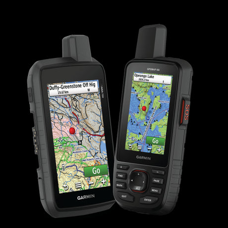
Whether you're heading out for a weekend ATV ride or exploring snow-covered backcountry trails, having the right maps on your Garmin GPS can make a big difference.
Canada has thousands of kilometres of motorized trails, forestry roads and remote recreation routes. Many take you well beyond reliable cell coverage, where knowing the next trail junction, staging area or access road becomes especially important.
Garmin offers several GPS devices designed for outdoor adventures and powersports, but the maps installed on your device are just as important as the GPS itself.
Here's what to look for when choosing Garmin GPS maps for ATV and snowmobile riding in Canada, and how Backroad GPS Maps can help you explore more.
 What Makes a Good GPS Map for ATV and Snowmobile Riding?
Not all GPS maps contain the same trail information. Some focus on general roads and topography, while others include specialized recreational routes and access points.
For ATV and snowmobile riders, the most useful mapping features include:
Detailed ATV and Snowmobile Trails
Look for maps that identify motorized trails separately from hiking paths, roads and other multi-use routes.
A map with dedicated ATV and snowmobile trail information can help you plan longer rides, identify trail connections and understand the surrounding network.
Backroads, Forestry Roads and Access Routes
Getting to the trailhead is often part of the adventure.
Detailed forest service roads, logging roads, secondary routes and other backcountry roads can be especially useful for riders travelling through remote parts of British Columbia, Alberta and other Canadian provinces.
Trailheads and Staging Areas
Knowing where to begin your ride matters.
Look for information on trailheads, staging areas and access locations. Nearby campgrounds, services and recreation sites can also help with planning multi-day adventures.
Topographic and Terrain Information
Elevation contours, rivers, lakes, mountain passes and other geographic features provide context for the terrain around you.
For snowmobilers travelling in mountainous areas, topographic information is particularly useful when reviewing a route. However, GPS maps do not replace avalanche forecasts, terrain training or current local conditions.
Offline Navigation
Riding often takes you outside reliable cell coverage.
With maps stored directly on a compatible Garmin GPS, you can continue viewing your location and map information without relying on a cellular connection.
Your device still needs adequate battery power or a reliable power connection, so prepare accordingly.
Garmin's Preloaded Maps vs Backroad GPS Maps
Many Garmin outdoor GPS devices come with TopoActive maps, while dedicated powersports models such as the Garmin Tread series may include additional off-road and snowmobile mapping.
These preloaded maps can already be useful for riding, and some Tread models include trail information from Canadian organizations and mapping providers.
For example, Garmin uses Backroad Mapbooks snowmobile trail data in several Canadian regions on supported Tread devices.
So why would you consider additional Backroad GPS Maps?
Our Garmin-licensed maps bring together extensive Canadian resource roads, motorized trails, topographic information, outdoor recreation points of interest and other backcountry features.
Depending on your device and the area you ride, they can provide additional information beyond what's included in your existing maps.
The best approach is to check your Garmin's current coverage and compare it with the Backroad GPS Maps available for your region.
Which Garmin GPS Is Best for ATV and Snowmobile Riding?
Different Garmin devices suit different styles of riding.

Garmin Tread: For ATV, UTV and Snowmobile Riders
The Garmin Tread series is designed specifically for powersports and off-road navigation.
These units offer larger displays, vehicle mounting options and features intended for riding in demanding conditions.
They're worth considering if you primarily want a GPS mounted on your ATV, side-by-side or snowmobile.
Some models already include specialized powersports maps and snowmobile trail coverage. Check the exact device and its installed maps before purchasing additional mapping.
Garmin Montana: For Multi-Activity Adventures
The Garmin Montana series offers a versatile option for people who enjoy ATV riding, hunting, overlanding, hiking and other backcountry activities.
Its touchscreen and mapping capabilities make it useful for riders who want one GPS device for multiple adventures.
The Montana 600 and 700 series are among the models recommended in our compatibility guide.
Garmin GPSMAP: For Handheld Backcountry Navigation
Garmin GPSMAP units are a popular option for outdoor enthusiasts who prefer physical buttons and a handheld format.
They're particularly useful for people who want a GPS they can carry between different activities, from scouting access roads to navigating on foot.
If your primary activity is ATV or snowmobile riding, consider whether you'd prefer a mounted, larger-screen unit instead.
Already own a Garmin? Before buying another device, check whether your existing GPS supports Backroad GPS Maps.
Check Garmin GPS Compatibility

What's New for ATV and Snowmobile Riders in Version 2027?
The latest Western Canada GPS Maps include several improvements that are particularly relevant to motorized recreation.
Across the Western Canada dataset, Version 2027 includes:
-
47,445 km of ATV trails, an increase of 1,526 km from the previous version.
-
58,786 km of snowmobile trails, an increase of 1,037 km.
-
76,315 km of multi-use trails, with additional routes and updated coverage.
-
Thousands of recreation features and expanded information on trailheads, staging areas, roads and access points.
These updates make V2027 worth considering if you use your Garmin to explore unfamiliar riding areas or want more recent trail and road information.
For the complete breakdown, visit our Version 2027 GPS Maps announcement.
Plug & Play microSD or Digital Download?
Backroad GPS Maps come in two formats, both containing the same mapping data.
Plug & Play microSD Cards
The simplest option for many riders. Insert the preloaded card into your compatible Garmin GPS, power on the device and access your maps without needing a computer for installation.
Digital Download
A flexible option if you prefer downloading and managing your maps through Garmin BaseCamp. Digital licenses also offer custom map combinations and support for certain compatible Garmin devices.
If you just want to get your Garmin ready for your next ride with minimal setup, Plug & Play is generally the easier option.
Compare Digital Download and Plug & Play GPS Maps

Five Tips for Navigating ATV and Snowmobile Trails with a Garmin
1. Check Your Maps Before You Leave
Make sure the correct region is installed, your maps display properly and you can identify your planned riding area.
2. Review Trail Access and Restrictions
A trail shown on your GPS isn't necessarily open to motorized use.
Check official trail association information, local access restrictions, landowner permissions, seasonal closures and any required permits before heading out.
3. Mark Important Waypoints
Save your staging area, parking location, campsite and other important points before starting your ride.
These can be useful references when navigating an unfamiliar area.
4. Prepare for Remote Conditions
Make sure your Garmin is adequately charged or connected to reliable power. Bring appropriate emergency equipment, and consider a satellite communicator if you're travelling outside cellular coverage.
For winter trips, also check weather, snow conditions and avalanche advisories where applicable.
5. Carry a Backup
Even dedicated GPS devices can lose power, suffer damage or fail.
A suitable paper map, a second navigation option and a trip plan shared with someone at home are sensible precautions for remote adventures.
Frequently Asked Questions
Can I use a Garmin GPS for ATV trails in Canada?
Yes. Many Garmin outdoor and powersports GPS devices support off-road mapping, including ATV and multi-use trails. Available detail depends on the device and installed map products.
Does the Garmin Tread already include snowmobile trails?
Some Tread devices include preloaded snowmobile trail information for Canada. Coverage and map providers vary by region, so check what's already installed before purchasing additional maps.
Will Backroad GPS Maps show which snowmobile trails are open?
The maps provide trail and recreation information, but they do not replace current trail status reports. Always check with the relevant snowmobile association for closures, grooming conditions and permit requirements.
Do I need cell service to use Backroad GPS Maps on a Garmin?
No. Once the maps are installed, they can be viewed without cellular coverage.
Can I use Backroad GPS Maps on any Garmin?
Not every Garmin model is supported. Compatibility depends on the model and map format. Check our compatibility guide before purchasing.

Get More Out of Your Garmin GPS
Whether you're exploring remote ATV trails in BC, heading into Alberta's backcountry or planning a winter snowmobile trip across the Prairies, detailed GPS maps can make planning and navigating easier.
Backroad GPS Maps bring Canadian road, trail, topographic and recreation information together on compatible Garmin devices, helping you explore beyond the main highways.
Find the coverage that matches your riding area and get ready for your next adventure.